You are here: Home > Network List > US - United States National Seismic Network Stations List
> Station MIAR Mount Ida, Arkansas, USA > Earthquake Result Viewer
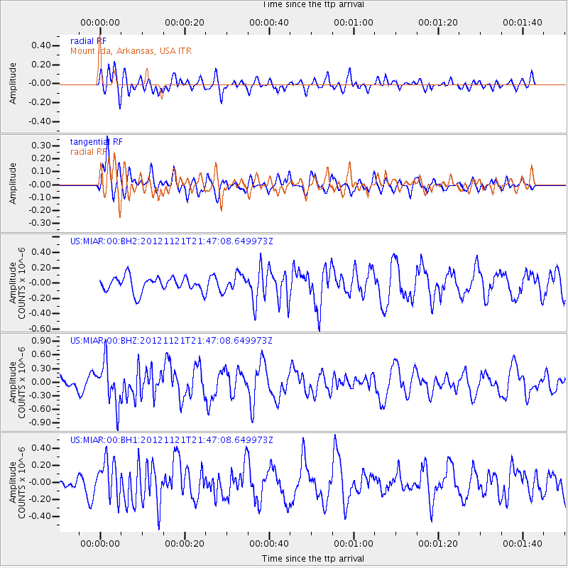
MIAR Mount Ida, Arkansas, USA - Earthquake Result Viewer
*The percent match for this event was below the threshold and hence no stack was calculated.
| Earthquake location: |
Near Coast Of Central Chile |
| Earthquake latitude/longitude: |
-33.9/-71.9 |
| Earthquake time(UTC): |
2012/11/21 (326) 21:36:22 GMT |
| Earthquake Depth: |
18 km |
| Earthquake Magnitude: |
5.7 MB, 5.5 MS, 5.9 MW, 5.8 MW |
| Earthquake Catalog/Contributor: |
WHDF/NEIC |
|
| Network: |
US United States National Seismic Network |
| Station: |
MIAR Mount Ida, Arkansas, USA |
| Lat/Lon: |
34.55 N/93.58 W |
| Elevation: |
207 m |
|
| Distance: |
71.1 deg |
| Az: |
341.173 deg |
| Baz: |
161.033 deg |
| Ray Param: |
$rayparam |
*The percent match for this event was below the threshold and hence was not used in the summary stack. |
|
| Radial Match: |
64.080284 % |
| Radial Bump: |
400 |
| Transverse Match: |
64.97519 % |
| Transverse Bump: |
400 |
| SOD ConfigId: |
558545 |
| Insert Time: |
2013-09-18 00:07:37.393 +0000 |
| GWidth: |
2.5 |
| Max Bumps: |
400 |
| Tol: |
0.001 |
|
Signal To Noise
| Channel | StoN | STA | LTA |
| US:MIAR:00:BHZ:20121121T21:47:08.649973Z | 2.4372072 | 4.7112687E-7 | 1.9330604E-7 |
| US:MIAR:00:BH1:20121121T21:47:08.649973Z | 2.0845687 | 2.2095152E-7 | 1.0599387E-7 |
| US:MIAR:00:BH2:20121121T21:47:08.649973Z | 1.0997914 | 1.069148E-7 | 9.721371E-8 |
| Arrivals |
| Ps | |
| PpPs | |
| PsPs/PpSs | |


