You are here: Home > Network List > US - United States National Seismic Network Stations List
> Station MNTX Cornudas Mountains, Texas, USA > Earthquake Result Viewer
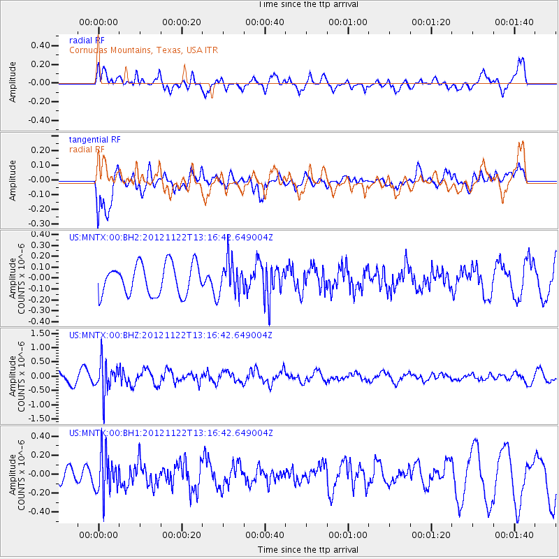
MNTX Cornudas Mountains, Texas, USA - Earthquake Result Viewer
*The percent match for this event was below the threshold and hence no stack was calculated.
| Earthquake location: |
Salta Province, Argentina |
| Earthquake latitude/longitude: |
-22.7/-63.6 |
| Earthquake time(UTC): |
2012/11/22 (327) 13:07:10 GMT |
| Earthquake Depth: |
517 km |
| Earthquake Magnitude: |
5.6 MB, 5.9 MW, 6.0 MW |
| Earthquake Catalog/Contributor: |
WHDF/NEIC |
|
| Network: |
US United States National Seismic Network |
| Station: |
MNTX Cornudas Mountains, Texas, USA |
| Lat/Lon: |
31.70 N/105.38 W |
| Elevation: |
404 m |
|
| Distance: |
67.3 deg |
| Az: |
321.984 deg |
| Baz: |
138.162 deg |
| Ray Param: |
$rayparam |
*The percent match for this event was below the threshold and hence was not used in the summary stack. |
|
| Radial Match: |
77.7214 % |
| Radial Bump: |
400 |
| Transverse Match: |
56.12541 % |
| Transverse Bump: |
400 |
| SOD ConfigId: |
558545 |
| Insert Time: |
2013-09-18 00:12:27.783 +0000 |
| GWidth: |
2.5 |
| Max Bumps: |
400 |
| Tol: |
0.001 |
|
Signal To Noise
| Channel | StoN | STA | LTA |
| US:MNTX:00:BHZ:20121122T13:16:42.649004Z | 2.7947695 | 5.45945E-7 | 1.9534528E-7 |
| US:MNTX:00:BH1:20121122T13:16:42.649004Z | 2.1762958 | 2.125705E-7 | 9.7675375E-8 |
| US:MNTX:00:BH2:20121122T13:16:42.649004Z | 1.0520849 | 1.4534011E-7 | 1.3814486E-7 |
| Arrivals |
| Ps | |
| PpPs | |
| PsPs/PpSs | |


