You are here: Home > Network List > IU - Global Seismograph Network (GSN - IRIS/USGS) Stations List
> Station HNR Honiara, Solomon Islands > Earthquake Result Viewer
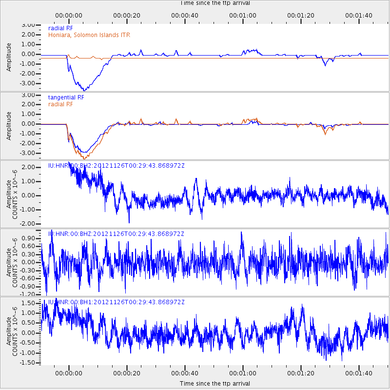
HNR Honiara, Solomon Islands - Earthquake Result Viewer
*The percent match for this event was below the threshold and hence no stack was calculated.
| Earthquake location: |
Central East Pacific Rise |
| Earthquake latitude/longitude: |
-9.1/-108.3 |
| Earthquake time(UTC): |
2012/11/26 (331) 00:17:14 GMT |
| Earthquake Depth: |
10 km |
| Earthquake Magnitude: |
5.5 MW |
| Earthquake Catalog/Contributor: |
NEIC PDE/NEIC PDE-W |
|
| Network: |
IU Global Seismograph Network (GSN - IRIS/USGS) |
| Station: |
HNR Honiara, Solomon Islands |
| Lat/Lon: |
9.44 S/159.95 E |
| Elevation: |
100 m |
|
| Distance: |
90.2 deg |
| Az: |
260.47 deg |
| Baz: |
99.197 deg |
| Ray Param: |
$rayparam |
*The percent match for this event was below the threshold and hence was not used in the summary stack. |
|
| Radial Match: |
35.60468 % |
| Radial Bump: |
400 |
| Transverse Match: |
37.74519 % |
| Transverse Bump: |
400 |
| SOD ConfigId: |
558545 |
| Insert Time: |
2013-09-18 00:14:18.710 +0000 |
| GWidth: |
2.5 |
| Max Bumps: |
400 |
| Tol: |
0.001 |
|
Signal To Noise
| Channel | StoN | STA | LTA |
| IU:HNR:00:BHZ:20121126T00:29:43.868972Z | 0.6090701 | 3.220412E-7 | 5.287424E-7 |
| IU:HNR:00:BH1:20121126T00:29:43.868972Z | 1.2162352 | 2.0182574E-6 | 1.6594302E-6 |
| IU:HNR:00:BH2:20121126T00:29:43.868972Z | 1.1529146 | 1.0474715E-6 | 9.085421E-7 |
| Arrivals |
| Ps | |
| PpPs | |
| PsPs/PpSs | |


