You are here: Home > Network List > CI - Caltech Regional Seismic Network Stations List
> Station SLA SLA, Trona, CA, USA > Earthquake Result Viewer
SLA SLA, Trona, CA, USA - Earthquake Result Viewer
*The percent match for this event was below the threshold and hence no stack was calculated.
| Earthquake location: |
Tonga Islands |
| Earthquake latitude/longitude: |
-21.0/-174.4 |
| Earthquake time(UTC): |
2008/10/09 (283) 17:49:58 GMT |
| Earthquake Depth: |
10 km |
| Earthquake Magnitude: |
5.8 MB, 5.6 MS, 5.9 MW, 5.9 MW |
| Earthquake Catalog/Contributor: |
WHDF/NEIC |
|
| Network: |
CI Caltech Regional Seismic Network |
| Station: |
SLA SLA, Trona, CA, USA |
| Lat/Lon: |
35.89 N/117.28 W |
| Elevation: |
1174 m |
|
| Distance: |
78.3 deg |
| Az: |
44.156 deg |
| Baz: |
233.269 deg |
| Ray Param: |
$rayparam |
*The percent match for this event was below the threshold and hence was not used in the summary stack. |
|
| Radial Match: |
62.42256 % |
| Radial Bump: |
400 |
| Transverse Match: |
70.7235 % |
| Transverse Bump: |
400 |
| SOD ConfigId: |
2560 |
| Insert Time: |
2010-02-25 20:36:32.862 +0000 |
| GWidth: |
2.5 |
| Max Bumps: |
400 |
| Tol: |
0.001 |
|
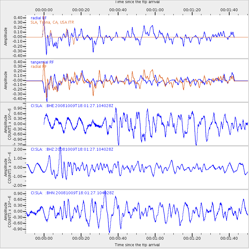
Signal To Noise
| Channel | StoN | STA | LTA |
| CI:SLA: :BHZ:20081009T18:01:27.104028Z | 3.15741 | 6.3675884E-7 | 2.0167127E-7 |
| CI:SLA: :BHN:20081009T18:01:27.104028Z | 1.4137108 | 2.7231897E-7 | 1.9262706E-7 |
| CI:SLA: :BHE:20081009T18:01:27.104028Z | 0.97905606 | 2.5983377E-7 | 2.6539212E-7 |
| Arrivals |
| Ps | |
| PpPs | |
| PsPs/PpSs | |


