You are here: Home > Network List > IU - Global Seismograph Network (GSN - IRIS/USGS) Stations List
> Station MAJO Matsushiro, Japan > Earthquake Result Viewer
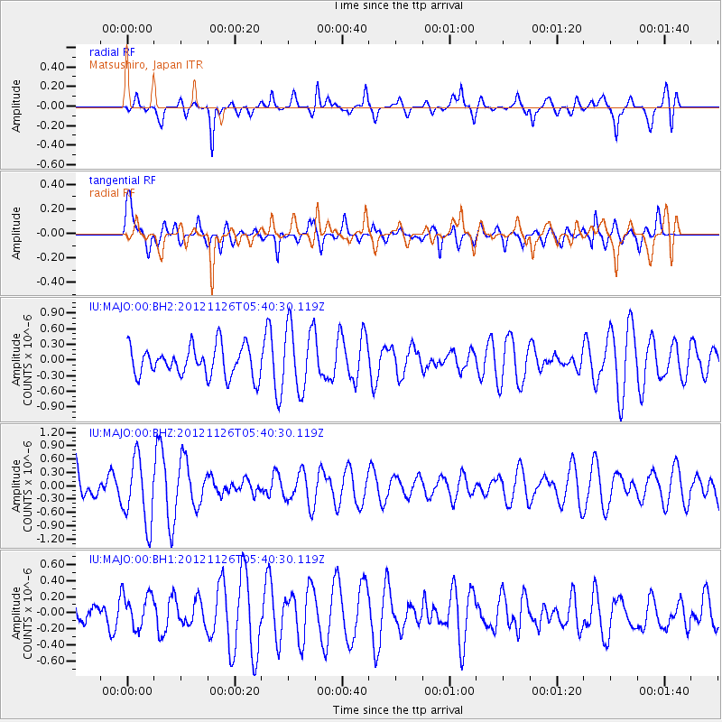
MAJO Matsushiro, Japan - Earthquake Result Viewer
*The percent match for this event was below the threshold and hence no stack was calculated.
| Earthquake location: |
Southern Xinjiang, China |
| Earthquake latitude/longitude: |
40.4/90.4 |
| Earthquake time(UTC): |
2012/11/26 (331) 05:33:48 GMT |
| Earthquake Depth: |
10 km |
| Earthquake Magnitude: |
5.6 MB, 5.0 MW, 5.1 MW |
| Earthquake Catalog/Contributor: |
WHDF/NEIC |
|
| Network: |
IU Global Seismograph Network (GSN - IRIS/USGS) |
| Station: |
MAJO Matsushiro, Japan |
| Lat/Lon: |
36.55 N/138.20 E |
| Elevation: |
405 m |
|
| Distance: |
37.3 deg |
| Az: |
80.144 deg |
| Baz: |
290.904 deg |
| Ray Param: |
$rayparam |
*The percent match for this event was below the threshold and hence was not used in the summary stack. |
|
| Radial Match: |
61.919167 % |
| Radial Bump: |
400 |
| Transverse Match: |
59.0405 % |
| Transverse Bump: |
400 |
| SOD ConfigId: |
558545 |
| Insert Time: |
2013-09-18 00:18:44.469 +0000 |
| GWidth: |
2.5 |
| Max Bumps: |
400 |
| Tol: |
0.001 |
|
Signal To Noise
| Channel | StoN | STA | LTA |
| IU:MAJO:00:BHZ:20121126T05:40:30.119Z | 1.5677221 | 7.41792E-7 | 4.7316553E-7 |
| IU:MAJO:00:BH1:20121126T05:40:30.119Z | 1.1205236 | 2.1242802E-7 | 1.8957925E-7 |
| IU:MAJO:00:BH2:20121126T05:40:30.119Z | 2.2151504 | 6.3101345E-7 | 2.8486258E-7 |
| Arrivals |
| Ps | |
| PpPs | |
| PsPs/PpSs | |


