You are here: Home > Network List > US - United States National Seismic Network Stations List
> Station EGMT Eagleton, Montana, USA > Earthquake Result Viewer
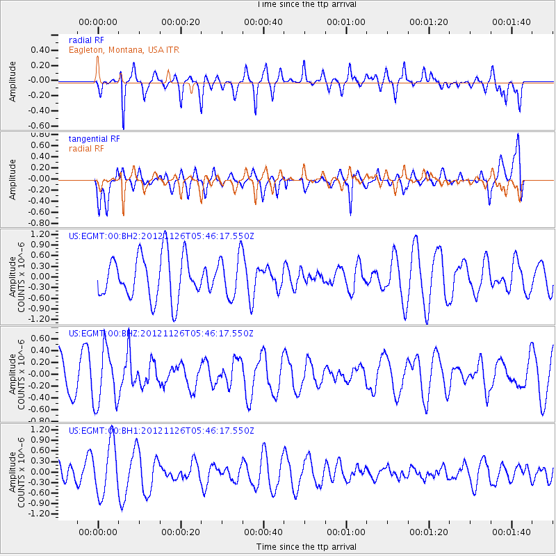
EGMT Eagleton, Montana, USA - Earthquake Result Viewer
*The percent match for this event was below the threshold and hence no stack was calculated.
| Earthquake location: |
Southern Xinjiang, China |
| Earthquake latitude/longitude: |
40.4/90.4 |
| Earthquake time(UTC): |
2012/11/26 (331) 05:33:48 GMT |
| Earthquake Depth: |
10 km |
| Earthquake Magnitude: |
5.6 MB, 5.0 MW, 5.1 MW |
| Earthquake Catalog/Contributor: |
WHDF/NEIC |
|
| Network: |
US United States National Seismic Network |
| Station: |
EGMT Eagleton, Montana, USA |
| Lat/Lon: |
48.02 N/109.75 W |
| Elevation: |
1055 m |
|
| Distance: |
90.2 deg |
| Az: |
13.345 deg |
| Baz: |
344.78 deg |
| Ray Param: |
$rayparam |
*The percent match for this event was below the threshold and hence was not used in the summary stack. |
|
| Radial Match: |
66.79554 % |
| Radial Bump: |
400 |
| Transverse Match: |
71.61894 % |
| Transverse Bump: |
400 |
| SOD ConfigId: |
558545 |
| Insert Time: |
2013-09-18 00:19:23.030 +0000 |
| GWidth: |
2.5 |
| Max Bumps: |
400 |
| Tol: |
0.001 |
|
Signal To Noise
| Channel | StoN | STA | LTA |
| US:EGMT:00:BHZ:20121126T05:46:17.550Z | 1.4864657 | 4.7598405E-7 | 3.2021194E-7 |
| US:EGMT:00:BH1:20121126T05:46:17.550Z | 3.3385472 | 7.576145E-7 | 2.2692939E-7 |
| US:EGMT:00:BH2:20121126T05:46:17.550Z | 0.9806945 | 6.052284E-7 | 6.171427E-7 |
| Arrivals |
| Ps | |
| PpPs | |
| PsPs/PpSs | |


