You are here: Home > Network List > US - United States National Seismic Network Stations List
> Station AMTX Amarillo, Texas, USA > Earthquake Result Viewer
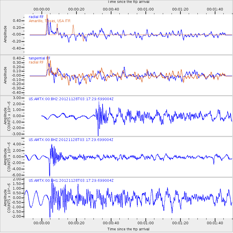
AMTX Amarillo, Texas, USA - Earthquake Result Viewer
*The percent match for this event was below the threshold and hence no stack was calculated.
| Earthquake location: |
Northern Peru |
| Earthquake latitude/longitude: |
-4.5/-76.1 |
| Earthquake time(UTC): |
2012/11/28 (333) 03:09:48 GMT |
| Earthquake Depth: |
118 km |
| Earthquake Magnitude: |
5.9 MB, 5.6 MW, 5.7 MW |
| Earthquake Catalog/Contributor: |
WHDF/NEIC |
|
| Network: |
US United States National Seismic Network |
| Station: |
AMTX Amarillo, Texas, USA |
| Lat/Lon: |
34.53 N/101.41 W |
| Elevation: |
1010 m |
|
| Distance: |
45.6 deg |
| Az: |
330.389 deg |
| Baz: |
143.37 deg |
| Ray Param: |
$rayparam |
*The percent match for this event was below the threshold and hence was not used in the summary stack. |
|
| Radial Match: |
67.81602 % |
| Radial Bump: |
400 |
| Transverse Match: |
69.31745 % |
| Transverse Bump: |
400 |
| SOD ConfigId: |
558545 |
| Insert Time: |
2013-09-18 00:23:25.181 +0000 |
| GWidth: |
2.5 |
| Max Bumps: |
400 |
| Tol: |
0.001 |
|
Signal To Noise
| Channel | StoN | STA | LTA |
| US:AMTX:00:BHZ:20121128T03:17:29.699004Z | 4.1273165 | 1.4676924E-6 | 3.5560453E-7 |
| US:AMTX:00:BH1:20121128T03:17:29.699004Z | 1.4020305 | 6.249066E-7 | 4.4571544E-7 |
| US:AMTX:00:BH2:20121128T03:17:29.699004Z | 1.362144 | 3.3645858E-7 | 2.4700662E-7 |
| Arrivals |
| Ps | |
| PpPs | |
| PsPs/PpSs | |


