You are here: Home > Network List > US - United States National Seismic Network Stations List
> Station MNTX Cornudas Mountains, Texas, USA > Earthquake Result Viewer
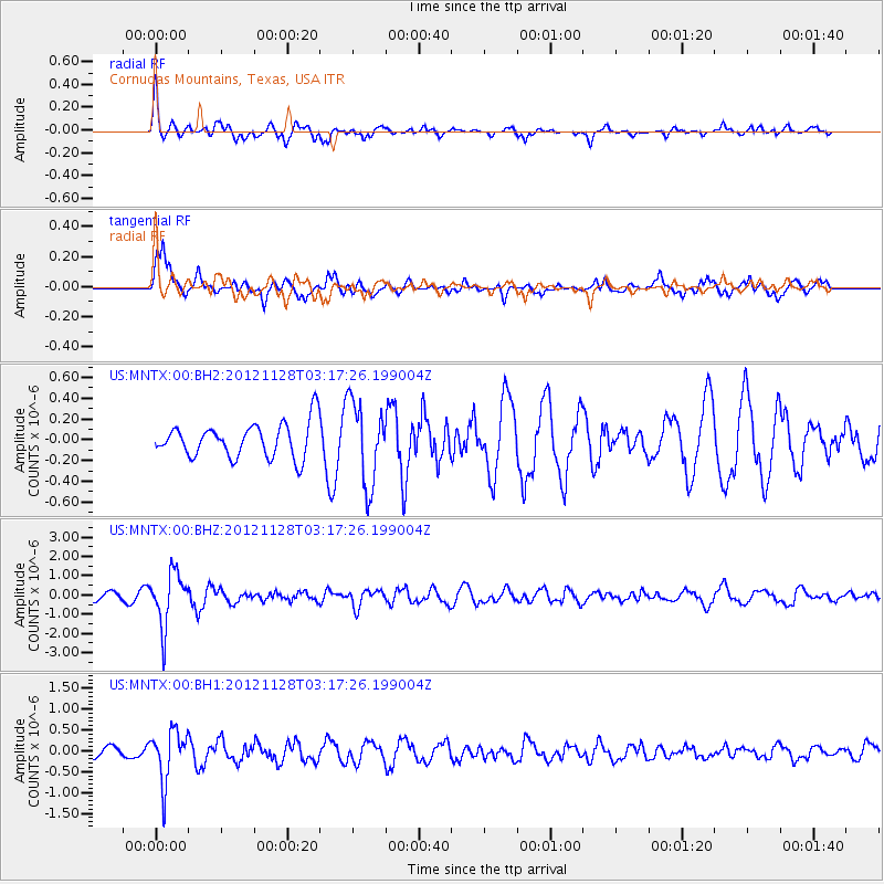
MNTX Cornudas Mountains, Texas, USA - Earthquake Result Viewer
*The percent match for this event was below the threshold and hence no stack was calculated.
| Earthquake location: |
Northern Peru |
| Earthquake latitude/longitude: |
-4.5/-76.1 |
| Earthquake time(UTC): |
2012/11/28 (333) 03:09:48 GMT |
| Earthquake Depth: |
118 km |
| Earthquake Magnitude: |
5.9 MB, 5.6 MW, 5.7 MW |
| Earthquake Catalog/Contributor: |
WHDF/NEIC |
|
| Network: |
US United States National Seismic Network |
| Station: |
MNTX Cornudas Mountains, Texas, USA |
| Lat/Lon: |
31.70 N/105.38 W |
| Elevation: |
404 m |
|
| Distance: |
45.6 deg |
| Az: |
324.269 deg |
| Baz: |
136.921 deg |
| Ray Param: |
$rayparam |
*The percent match for this event was below the threshold and hence was not used in the summary stack. |
|
| Radial Match: |
76.29164 % |
| Radial Bump: |
388 |
| Transverse Match: |
82.057686 % |
| Transverse Bump: |
378 |
| SOD ConfigId: |
558545 |
| Insert Time: |
2013-09-18 00:25:02.496 +0000 |
| GWidth: |
2.5 |
| Max Bumps: |
400 |
| Tol: |
0.001 |
|
Signal To Noise
| Channel | StoN | STA | LTA |
| US:MNTX:00:BHZ:20121128T03:17:26.199004Z | 9.690562 | 1.3799961E-6 | 1.424062E-7 |
| US:MNTX:00:BH1:20121128T03:17:26.199004Z | 3.4979973 | 6.084706E-7 | 1.7394827E-7 |
| US:MNTX:00:BH2:20121128T03:17:26.199004Z | 2.4216895 | 3.991362E-7 | 1.6481725E-7 |
| Arrivals |
| Ps | |
| PpPs | |
| PsPs/PpSs | |


