You are here: Home > Network List > IU - Global Seismograph Network (GSN - IRIS/USGS) Stations List
> Station POHA Pohakuloa, Hawaii, USA > Earthquake Result Viewer
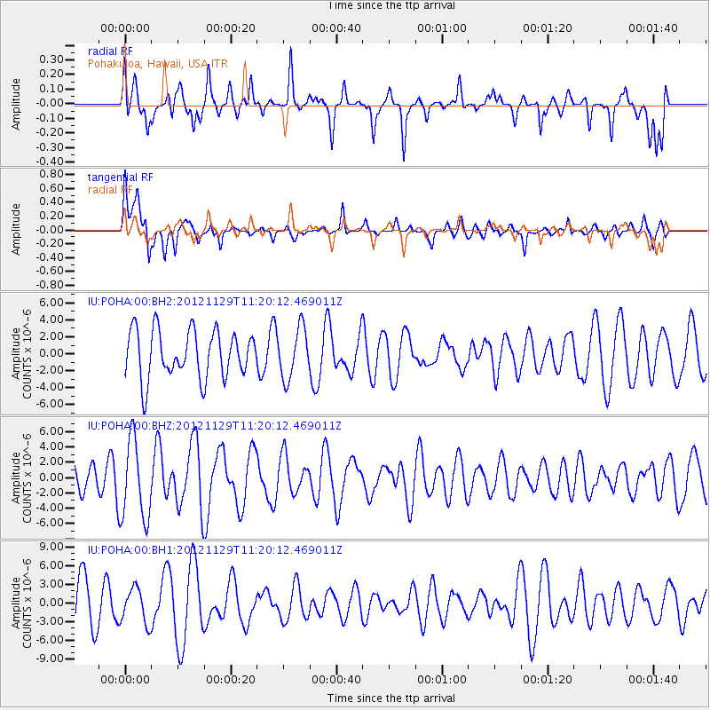
POHA Pohakuloa, Hawaii, USA - Earthquake Result Viewer
*The percent match for this event was below the threshold and hence no stack was calculated.
| Earthquake location: |
Near N Coast Of New Guinea, P.N.G. |
| Earthquake latitude/longitude: |
-3.4/145.6 |
| Earthquake time(UTC): |
2012/11/29 (334) 11:10:21 GMT |
| Earthquake Depth: |
10 km |
| Earthquake Magnitude: |
5.7 MB, 5.9 MS, 5.9 MW, 5.9 MW |
| Earthquake Catalog/Contributor: |
WHDF/NEIC |
|
| Network: |
IU Global Seismograph Network (GSN - IRIS/USGS) |
| Station: |
POHA Pohakuloa, Hawaii, USA |
| Lat/Lon: |
19.76 N/155.53 W |
| Elevation: |
1990 m |
|
| Distance: |
62.2 deg |
| Az: |
65.692 deg |
| Baz: |
254.997 deg |
| Ray Param: |
$rayparam |
*The percent match for this event was below the threshold and hence was not used in the summary stack. |
|
| Radial Match: |
50.49198 % |
| Radial Bump: |
400 |
| Transverse Match: |
60.184967 % |
| Transverse Bump: |
400 |
| SOD ConfigId: |
558545 |
| Insert Time: |
2013-09-18 00:33:42.812 +0000 |
| GWidth: |
2.5 |
| Max Bumps: |
400 |
| Tol: |
0.001 |
|
Signal To Noise
| Channel | StoN | STA | LTA |
| IU:POHA:00:BHZ:20121129T11:20:12.469011Z | 2.9034095 | 5.2119212E-6 | 1.7951038E-6 |
| IU:POHA:00:BH1:20121129T11:20:12.469011Z | 0.8423329 | 2.8623203E-6 | 3.3980868E-6 |
| IU:POHA:00:BH2:20121129T11:20:12.469011Z | 1.0596805 | 2.9750365E-6 | 2.8074846E-6 |
| Arrivals |
| Ps | |
| PpPs | |
| PsPs/PpSs | |


