You are here: Home > Network List > US - United States National Seismic Network Stations List
> Station EGMT Eagleton, Montana, USA > Earthquake Result Viewer
EGMT Eagleton, Montana, USA - Earthquake Result Viewer
*The percent match for this event was below the threshold and hence no stack was calculated.
| Earthquake location: |
Off Coast Of Chiapas, Mexico |
| Earthquake latitude/longitude: |
13.8/-92.1 |
| Earthquake time(UTC): |
2012/11/29 (334) 19:32:31 GMT |
| Earthquake Depth: |
10 km |
| Earthquake Magnitude: |
5.5 MW |
| Earthquake Catalog/Contributor: |
NEIC PDE/NEIC PDE-W |
|
| Network: |
US United States National Seismic Network |
| Station: |
EGMT Eagleton, Montana, USA |
| Lat/Lon: |
48.02 N/109.75 W |
| Elevation: |
1055 m |
|
| Distance: |
37.2 deg |
| Az: |
340.326 deg |
| Baz: |
150.836 deg |
| Ray Param: |
$rayparam |
*The percent match for this event was below the threshold and hence was not used in the summary stack. |
|
| Radial Match: |
51.8937 % |
| Radial Bump: |
365 |
| Transverse Match: |
63.560986 % |
| Transverse Bump: |
400 |
| SOD ConfigId: |
558545 |
| Insert Time: |
2013-09-18 00:36:05.812 +0000 |
| GWidth: |
2.5 |
| Max Bumps: |
400 |
| Tol: |
0.001 |
|
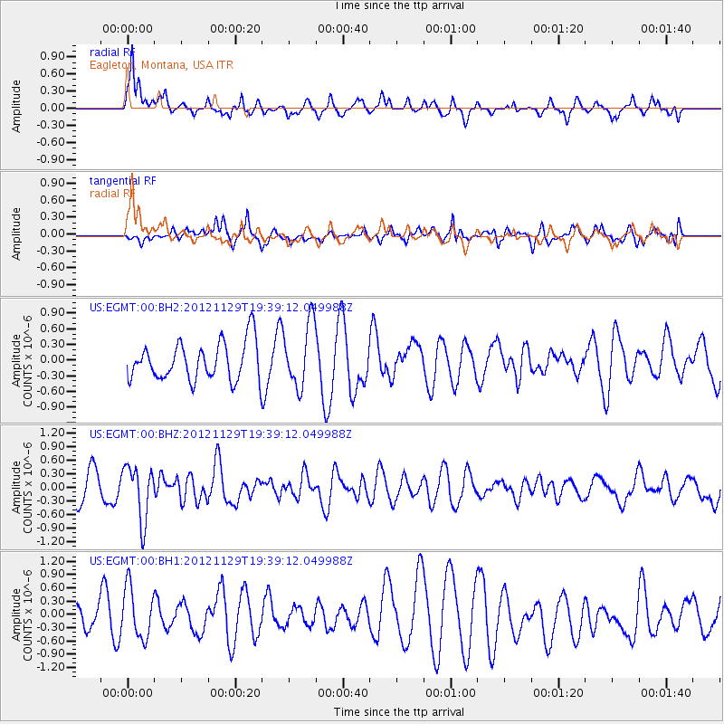
Signal To Noise
| Channel | StoN | STA | LTA |
| US:EGMT:00:BHZ:20121129T19:39:12.049988Z | 1.8523506 | 6.0355035E-7 | 3.2582943E-7 |
| US:EGMT:00:BH1:20121129T19:39:12.049988Z | 1.059857 | 5.8644093E-7 | 5.5332083E-7 |
| US:EGMT:00:BH2:20121129T19:39:12.049988Z | 1.6883377 | 6.171186E-7 | 3.6551847E-7 |
| Arrivals |
| Ps | |
| PpPs | |
| PsPs/PpSs | |


