You are here: Home > Network List > US - United States National Seismic Network Stations List
> Station MSO Missoula, Montana, USA > Earthquake Result Viewer
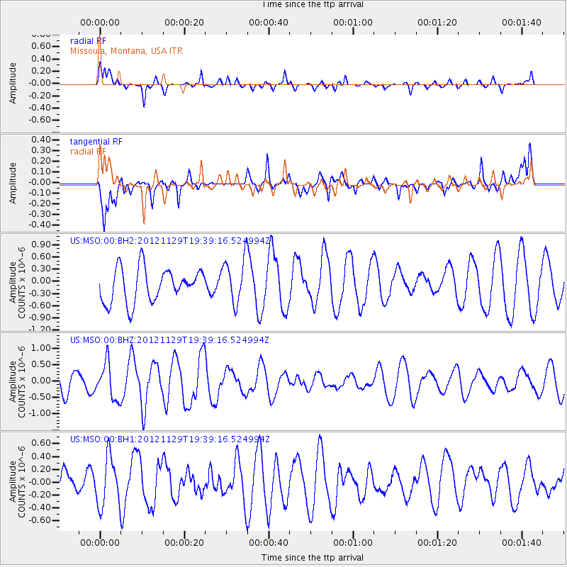
MSO Missoula, Montana, USA - Earthquake Result Viewer
*The percent match for this event was below the threshold and hence no stack was calculated.
| Earthquake location: |
Off Coast Of Chiapas, Mexico |
| Earthquake latitude/longitude: |
13.8/-92.1 |
| Earthquake time(UTC): |
2012/11/29 (334) 19:32:31 GMT |
| Earthquake Depth: |
10 km |
| Earthquake Magnitude: |
5.5 MW |
| Earthquake Catalog/Contributor: |
NEIC PDE/NEIC PDE-W |
|
| Network: |
US United States National Seismic Network |
| Station: |
MSO Missoula, Montana, USA |
| Lat/Lon: |
46.83 N/113.94 W |
| Elevation: |
1264 m |
|
| Distance: |
37.7 deg |
| Az: |
335.33 deg |
| Baz: |
143.795 deg |
| Ray Param: |
$rayparam |
*The percent match for this event was below the threshold and hence was not used in the summary stack. |
|
| Radial Match: |
58.653477 % |
| Radial Bump: |
375 |
| Transverse Match: |
67.76672 % |
| Transverse Bump: |
400 |
| SOD ConfigId: |
558545 |
| Insert Time: |
2013-09-18 00:36:23.289 +0000 |
| GWidth: |
2.5 |
| Max Bumps: |
400 |
| Tol: |
0.001 |
|
Signal To Noise
| Channel | StoN | STA | LTA |
| US:MSO:00:BHZ:20121129T19:39:16.524994Z | 1.7887815 | 5.591049E-7 | 3.1256187E-7 |
| US:MSO:00:BH1:20121129T19:39:16.524994Z | 1.034574 | 3.9529144E-7 | 3.8208134E-7 |
| US:MSO:00:BH2:20121129T19:39:16.524994Z | 1.360929 | 5.657981E-7 | 4.1574398E-7 |
| Arrivals |
| Ps | |
| PpPs | |
| PsPs/PpSs | |


