You are here: Home > Network List > II - Global Seismograph Network (GSN - IRIS/IDA) Stations List
> Station WRAB Tennant Creek, NT, Australia > Earthquake Result Viewer
WRAB Tennant Creek, NT, Australia - Earthquake Result Viewer
*The percent match for this event was below the threshold and hence no stack was calculated.
| Earthquake location: |
Tonga Islands |
| Earthquake latitude/longitude: |
-18.8/-175.6 |
| Earthquake time(UTC): |
2012/11/30 (335) 11:20:38 GMT |
| Earthquake Depth: |
200 km |
| Earthquake Magnitude: |
5.7 MW, 5.1 MB, 5.7 MW |
| Earthquake Catalog/Contributor: |
WHDF/NEIC |
|
| Network: |
II Global Seismograph Network (GSN - IRIS/IDA) |
| Station: |
WRAB Tennant Creek, NT, Australia |
| Lat/Lon: |
19.93 S/134.36 E |
| Elevation: |
366 m |
|
| Distance: |
47.1 deg |
| Az: |
259.995 deg |
| Baz: |
97.501 deg |
| Ray Param: |
$rayparam |
*The percent match for this event was below the threshold and hence was not used in the summary stack. |
|
| Radial Match: |
45.455086 % |
| Radial Bump: |
400 |
| Transverse Match: |
76.36771 % |
| Transverse Bump: |
400 |
| SOD ConfigId: |
558545 |
| Insert Time: |
2013-09-18 00:37:33.810 +0000 |
| GWidth: |
2.5 |
| Max Bumps: |
400 |
| Tol: |
0.001 |
|
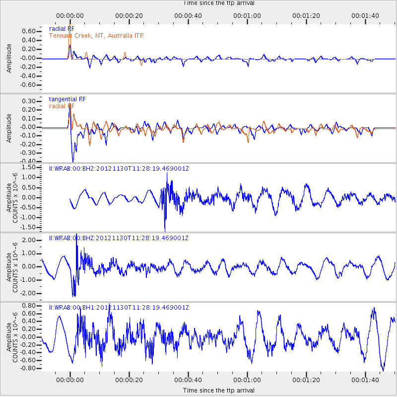
Signal To Noise
| Channel | StoN | STA | LTA |
| II:WRAB:00:BHZ:20121130T11:28:19.469001Z | 2.2159402 | 1.0303445E-6 | 4.6496945E-7 |
| II:WRAB:00:BH1:20121130T11:28:19.469001Z | 1.8392508 | 3.9916597E-7 | 2.170264E-7 |
| II:WRAB:00:BH2:20121130T11:28:19.469001Z | 2.503412 | 5.2837635E-7 | 2.110625E-7 |
| Arrivals |
| Ps | |
| PpPs | |
| PsPs/PpSs | |


