You are here: Home > Network List > II - Global Seismograph Network (GSN - IRIS/IDA) Stations List
> Station KAPI Kappang, Sulawesi, Indonesia > Earthquake Result Viewer
KAPI Kappang, Sulawesi, Indonesia - Earthquake Result Viewer
| Earthquake location: |
Vanuatu Islands |
| Earthquake latitude/longitude: |
-17.0/167.6 |
| Earthquake time(UTC): |
2012/12/02 (337) 00:54:22 GMT |
| Earthquake Depth: |
32 km |
| Earthquake Magnitude: |
6.1 MB, 6.0 MS, 6.1 MW, 6.2 MW |
| Earthquake Catalog/Contributor: |
WHDF/NEIC |
|
| Network: |
II Global Seismograph Network (GSN - IRIS/IDA) |
| Station: |
KAPI Kappang, Sulawesi, Indonesia |
| Lat/Lon: |
5.01 S/119.75 E |
| Elevation: |
300 m |
|
| Distance: |
48.4 deg |
| Az: |
278.521 deg |
| Baz: |
108.195 deg |
| Ray Param: |
0.06935047 |
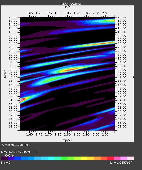
| Estimated Moho Depth: |
53.75 km |
| Estimated Crust Vp/Vs: |
1.60 |
| Assumed Crust Vp: |
6.343 km/s |
| Estimated Crust Vs: |
3.965 km/s |
| Estimated Crust Poisson's Ratio: |
0.18 |
|
| Radial Match: |
93.81912 % |
| Radial Bump: |
400 |
| Transverse Match: |
87.85306 % |
| Transverse Bump: |
400 |
| SOD ConfigId: |
558545 |
| Insert Time: |
2013-09-18 00:47:23.692 +0000 |
| GWidth: |
2.5 |
| Max Bumps: |
400 |
| Tol: |
0.001 |
|
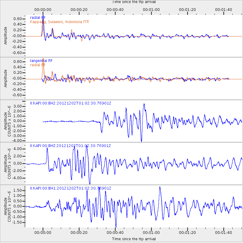
Signal To Noise
| Channel | StoN | STA | LTA |
| II:KAPI:00:BHZ:20121202T01:02:30.76901Z | 14.269182 | 1.6681456E-6 | 1.1690548E-7 |
| II:KAPI:00:BH1:20121202T01:02:30.76901Z | 4.7066474 | 2.2696221E-7 | 4.822163E-8 |
| II:KAPI:00:BH2:20121202T01:02:30.76901Z | 20.232912 | 1.0445513E-6 | 5.162634E-8 |
| Arrivals |
| Ps | 5.4 SECOND |
| PpPs | 21 SECOND |
| PsPs/PpSs | 26 SECOND |


