You are here: Home > Network List > IU - Global Seismograph Network (GSN - IRIS/USGS) Stations List
> Station JOHN Johnston Island, USA > Earthquake Result Viewer
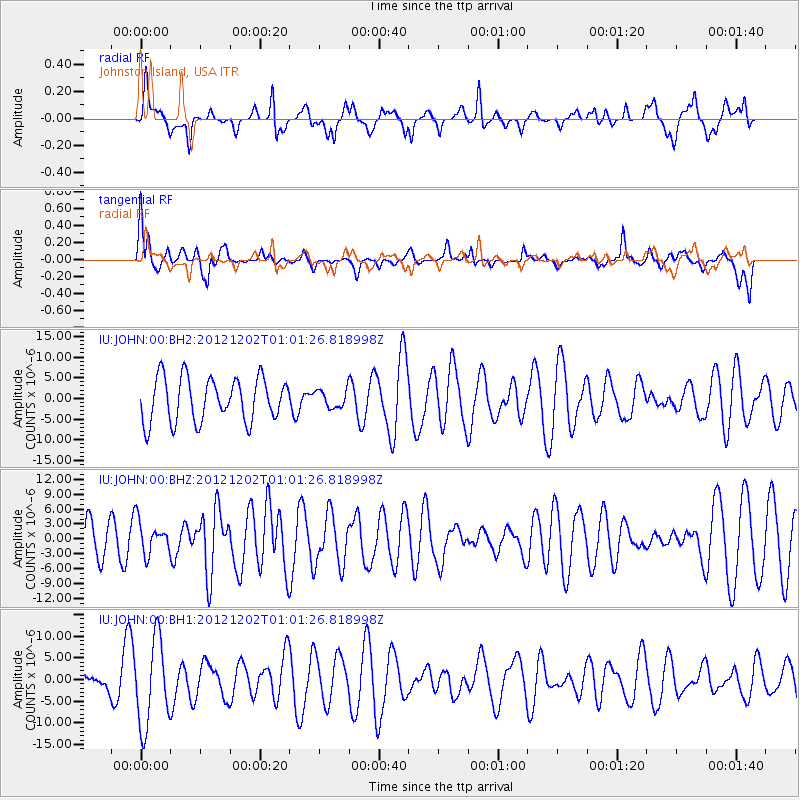
JOHN Johnston Island, USA - Earthquake Result Viewer
*The percent match for this event was below the threshold and hence no stack was calculated.
| Earthquake location: |
Vanuatu Islands |
| Earthquake latitude/longitude: |
-17.0/167.6 |
| Earthquake time(UTC): |
2012/12/02 (337) 00:54:22 GMT |
| Earthquake Depth: |
32 km |
| Earthquake Magnitude: |
6.1 MB, 6.0 MS, 6.1 MW, 6.2 MW |
| Earthquake Catalog/Contributor: |
WHDF/NEIC |
|
| Network: |
IU Global Seismograph Network (GSN - IRIS/USGS) |
| Station: |
JOHN Johnston Island, USA |
| Lat/Lon: |
16.73 N/169.53 W |
| Elevation: |
2.0 m |
|
| Distance: |
40.3 deg |
| Az: |
35.039 deg |
| Baz: |
214.988 deg |
| Ray Param: |
$rayparam |
*The percent match for this event was below the threshold and hence was not used in the summary stack. |
|
| Radial Match: |
52.638508 % |
| Radial Bump: |
393 |
| Transverse Match: |
60.875034 % |
| Transverse Bump: |
400 |
| SOD ConfigId: |
558545 |
| Insert Time: |
2013-09-18 00:48:28.698 +0000 |
| GWidth: |
2.5 |
| Max Bumps: |
400 |
| Tol: |
0.001 |
|
Signal To Noise
| Channel | StoN | STA | LTA |
| IU:JOHN:00:BHZ:20121202T01:01:26.818998Z | 0.772979 | 3.2628088E-6 | 4.221083E-6 |
| IU:JOHN:00:BH1:20121202T01:01:26.818998Z | 3.202 | 1.0020744E-5 | 3.1295267E-6 |
| IU:JOHN:00:BH2:20121202T01:01:26.818998Z | 0.40614095 | 2.1556732E-6 | 5.3076974E-6 |
| Arrivals |
| Ps | |
| PpPs | |
| PsPs/PpSs | |


