You are here: Home > Network List > IU - Global Seismograph Network (GSN - IRIS/USGS) Stations List
> Station MBWA Marble Bar, Western Australia > Earthquake Result Viewer
MBWA Marble Bar, Western Australia - Earthquake Result Viewer
| Earthquake location: |
Vanuatu Islands |
| Earthquake latitude/longitude: |
-17.0/167.6 |
| Earthquake time(UTC): |
2012/12/02 (337) 00:54:22 GMT |
| Earthquake Depth: |
32 km |
| Earthquake Magnitude: |
6.1 MB, 6.0 MS, 6.1 MW, 6.2 MW |
| Earthquake Catalog/Contributor: |
WHDF/NEIC |
|
| Network: |
IU Global Seismograph Network (GSN - IRIS/USGS) |
| Station: |
MBWA Marble Bar, Western Australia |
| Lat/Lon: |
21.16 S/119.73 E |
| Elevation: |
190 m |
|
| Distance: |
45.3 deg |
| Az: |
256.846 deg |
| Baz: |
93.277 deg |
| Ray Param: |
0.07127384 |
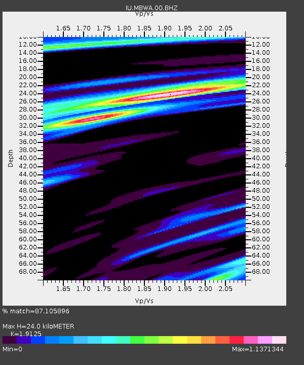
| Estimated Moho Depth: |
24.0 km |
| Estimated Crust Vp/Vs: |
1.91 |
| Assumed Crust Vp: |
6.464 km/s |
| Estimated Crust Vs: |
3.38 km/s |
| Estimated Crust Poisson's Ratio: |
0.31 |
|
| Radial Match: |
87.105896 % |
| Radial Bump: |
316 |
| Transverse Match: |
80.635025 % |
| Transverse Bump: |
400 |
| SOD ConfigId: |
558545 |
| Insert Time: |
2013-09-18 00:48:49.687 +0000 |
| GWidth: |
2.5 |
| Max Bumps: |
400 |
| Tol: |
0.001 |
|

Signal To Noise
| Channel | StoN | STA | LTA |
| IU:MBWA:00:BHZ:20121202T01:02:07.26901Z | 4.1112843 | 1.3828159E-6 | 3.3634646E-7 |
| IU:MBWA:00:BH1:20121202T01:02:07.26901Z | 2.1904066 | 4.002915E-7 | 1.8274757E-7 |
| IU:MBWA:00:BH2:20121202T01:02:07.26901Z | 2.0944138 | 7.4299743E-7 | 3.5475196E-7 |
| Arrivals |
| Ps | 3.6 SECOND |
| PpPs | 10 SECOND |
| PsPs/PpSs | 14 SECOND |


