You are here: Home > Network List > US - United States National Seismic Network Stations List
> Station DUG Dugway, Tooele County, Utah, USA > Earthquake Result Viewer
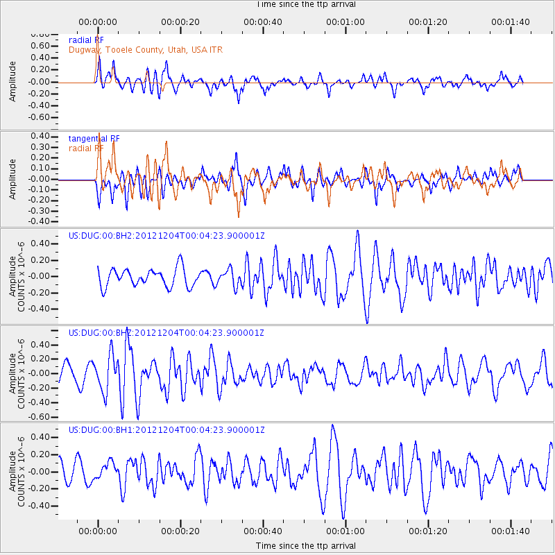
DUG Dugway, Tooele County, Utah, USA - Earthquake Result Viewer
*The percent match for this event was below the threshold and hence no stack was calculated.
| Earthquake location: |
Near Coast Of Chiapas, Mexico |
| Earthquake latitude/longitude: |
14.2/-92.4 |
| Earthquake time(UTC): |
2012/12/03 (338) 23:58:35 GMT |
| Earthquake Depth: |
35 km |
| Earthquake Magnitude: |
5.6 MD |
| Earthquake Catalog/Contributor: |
NEIC PDE/NEIC PDE-W |
|
| Network: |
US United States National Seismic Network |
| Station: |
DUG Dugway, Tooele County, Utah, USA |
| Lat/Lon: |
40.19 N/112.81 W |
| Elevation: |
1477 m |
|
| Distance: |
31.5 deg |
| Az: |
329.219 deg |
| Baz: |
139.604 deg |
| Ray Param: |
$rayparam |
*The percent match for this event was below the threshold and hence was not used in the summary stack. |
|
| Radial Match: |
79.945564 % |
| Radial Bump: |
400 |
| Transverse Match: |
70.59006 % |
| Transverse Bump: |
400 |
| SOD ConfigId: |
558545 |
| Insert Time: |
2013-09-18 00:58:00.022 +0000 |
| GWidth: |
2.5 |
| Max Bumps: |
400 |
| Tol: |
0.001 |
|
Signal To Noise
| Channel | StoN | STA | LTA |
| US:DUG:00:BHZ:20121204T00:04:23.900001Z | 2.1760328 | 2.4962984E-7 | 1.14717864E-7 |
| US:DUG:00:BH1:20121204T00:04:23.900001Z | 0.8777271 | 9.1725866E-8 | 1.0450385E-7 |
| US:DUG:00:BH2:20121204T00:04:23.900001Z | 0.89942425 | 9.817837E-8 | 1.091569E-7 |
| Arrivals |
| Ps | |
| PpPs | |
| PsPs/PpSs | |


