You are here: Home > Network List > CI - Caltech Regional Seismic Network Stations List
> Station SLA SLA, Trona, CA, USA > Earthquake Result Viewer
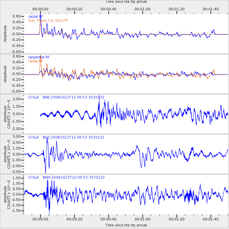
SLA SLA, Trona, CA, USA - Earthquake Result Viewer
*The percent match for this event was below the threshold and hence no stack was calculated.
| Earthquake location: |
Tonga Islands |
| Earthquake latitude/longitude: |
-18.4/-175.4 |
| Earthquake time(UTC): |
2008/10/22 (296) 12:55:57 GMT |
| Earthquake Depth: |
233 km |
| Earthquake Magnitude: |
5.9 MB, 6.4 MW, 6.3 MW |
| Earthquake Catalog/Contributor: |
WHDF/NEIC |
|
| Network: |
CI Caltech Regional Seismic Network |
| Station: |
SLA SLA, Trona, CA, USA |
| Lat/Lon: |
35.89 N/117.28 W |
| Elevation: |
1174 m |
|
| Distance: |
77.0 deg |
| Az: |
45.005 deg |
| Baz: |
235.778 deg |
| Ray Param: |
$rayparam |
*The percent match for this event was below the threshold and hence was not used in the summary stack. |
|
| Radial Match: |
77.834564 % |
| Radial Bump: |
400 |
| Transverse Match: |
67.076324 % |
| Transverse Bump: |
400 |
| SOD ConfigId: |
2560 |
| Insert Time: |
2010-02-25 20:36:36.297 +0000 |
| GWidth: |
2.5 |
| Max Bumps: |
400 |
| Tol: |
0.001 |
|
Signal To Noise
| Channel | StoN | STA | LTA |
| CI:SLA: :BHZ:20081022T13:06:53.353013Z | 6.6886487 | 1.2650589E-6 | 1.8913519E-7 |
| CI:SLA: :BHN:20081022T13:06:53.353013Z | 1.3079352 | 3.6003075E-7 | 2.752665E-7 |
| CI:SLA: :BHE:20081022T13:06:53.353013Z | 2.518797 | 6.6682065E-7 | 2.6473776E-7 |
| Arrivals |
| Ps | |
| PpPs | |
| PsPs/PpSs | |


