You are here: Home > Network List > IU - Global Seismograph Network (GSN - IRIS/USGS) Stations List
> Station CTAO Charters Towers, Australia > Earthquake Result Viewer
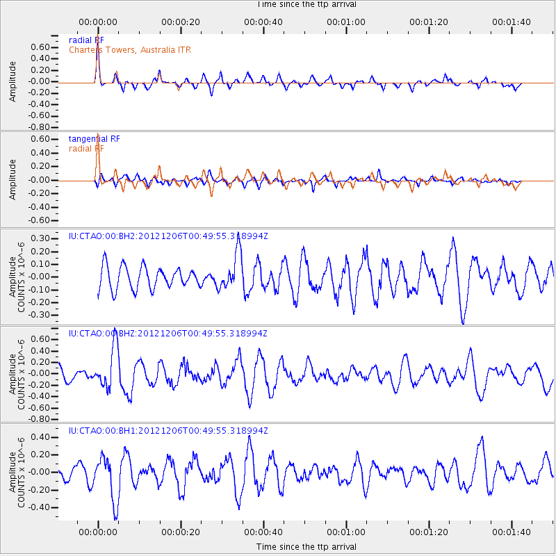
CTAO Charters Towers, Australia - Earthquake Result Viewer
*The percent match for this event was below the threshold and hence no stack was calculated.
| Earthquake location: |
Philippine Islands Region |
| Earthquake latitude/longitude: |
11.0/126.6 |
| Earthquake time(UTC): |
2012/12/06 (341) 00:43:24 GMT |
| Earthquake Depth: |
31 km |
| Earthquake Magnitude: |
5.5 MW |
| Earthquake Catalog/Contributor: |
NEIC PDE/NEIC PDE-W |
|
| Network: |
IU Global Seismograph Network (GSN - IRIS/USGS) |
| Station: |
CTAO Charters Towers, Australia |
| Lat/Lon: |
20.09 S/146.25 E |
| Elevation: |
357 m |
|
| Distance: |
36.4 deg |
| Az: |
147.885 deg |
| Baz: |
326.261 deg |
| Ray Param: |
$rayparam |
*The percent match for this event was below the threshold and hence was not used in the summary stack. |
|
| Radial Match: |
73.12165 % |
| Radial Bump: |
387 |
| Transverse Match: |
60.128075 % |
| Transverse Bump: |
400 |
| SOD ConfigId: |
558545 |
| Insert Time: |
2013-09-18 01:11:36.640 +0000 |
| GWidth: |
2.5 |
| Max Bumps: |
400 |
| Tol: |
0.001 |
|
Signal To Noise
| Channel | StoN | STA | LTA |
| IU:CTAO:00:BHZ:20121206T00:49:55.318994Z | 2.3132923 | 3.79891E-7 | 1.6422092E-7 |
| IU:CTAO:00:BH1:20121206T00:49:55.318994Z | 2.3743846 | 2.5962095E-7 | 1.0934241E-7 |
| IU:CTAO:00:BH2:20121206T00:49:55.318994Z | 1.7742326 | 1.518995E-7 | 8.56142E-8 |
| Arrivals |
| Ps | |
| PpPs | |
| PsPs/PpSs | |


