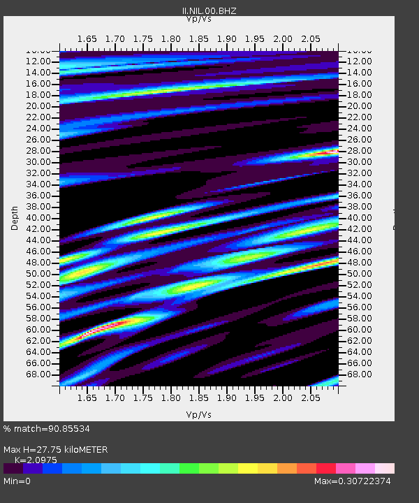
NIL Nilore, Pakistan - Earthquake Result Viewer
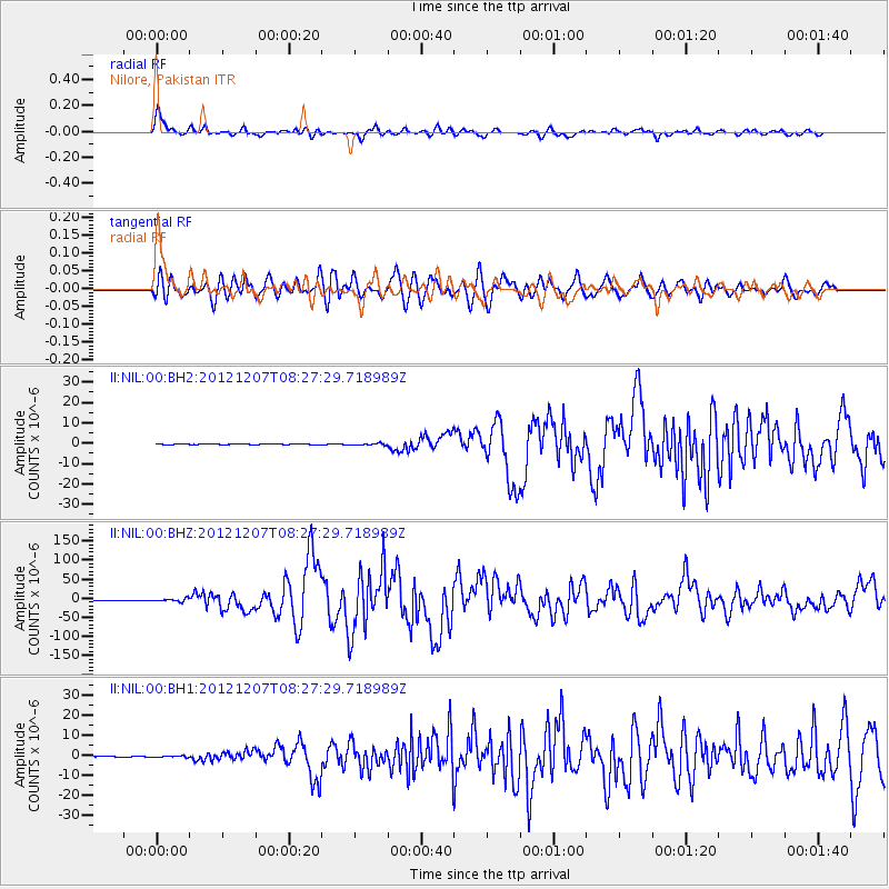
Earthquake location: Off East Coast Of Honshu, Japan
Earthquake latitude/longitude: 37.9/143.9
Earthquake time(UTC): 2012/12/07 (342) 08:18:23 GMT
Earthquake Depth: 31 km
Earthquake Magnitude: 7.2 MB, 7.3 MS, 7.3 MW, 7.3 MW
Earthquake Catalog/Contributor: WHDF/NEIC
Network: II Global Seismograph Network (GSN - IRIS/IDA)
Station: NIL Nilore, Pakistan
Lat/Lon: 33.65 N/73.27 E
Elevation: 629 m
Distance: 56.2 deg
Az: 288.776 deg
Baz: 63.9 deg
Ray Param: 0.0642147
Estimated Moho Depth: 27.75 km
Estimated Crust Vp/Vs: 2.10
Assumed Crust Vp: 6.242 km/s
Estimated Crust Vs: 2.976 km/s
Estimated Crust Poisson's Ratio: 0.35
Radial Match: 90.85534 %
Radial Bump: 400
Transverse Match: 83.19024 %
Transverse Bump: 400
SOD ConfigId: 558545
Insert Time: 2013-09-18 01:14:25.775 +0000
GWidth: 2.5
Max Bumps: 400
Tol: 0.001

Signal To Noise

ChannelStoNSTALTA
II:NIL:00:BHZ:20121207T08:27:29.718989Z22.1908174.3330033E-61.9526108E-7
II:NIL:00:BH1:20121207T08:27:29.718989Z5.91470053.4803844E-75.8842954E-8
II:NIL:00:BH2:20121207T08:27:29.718989Z5.0228324.1733884E-78.308835E-8
Arrivals
Ps5.1 SECOND
PpPs13 SECOND
PsPs/PpSs18 SECOND