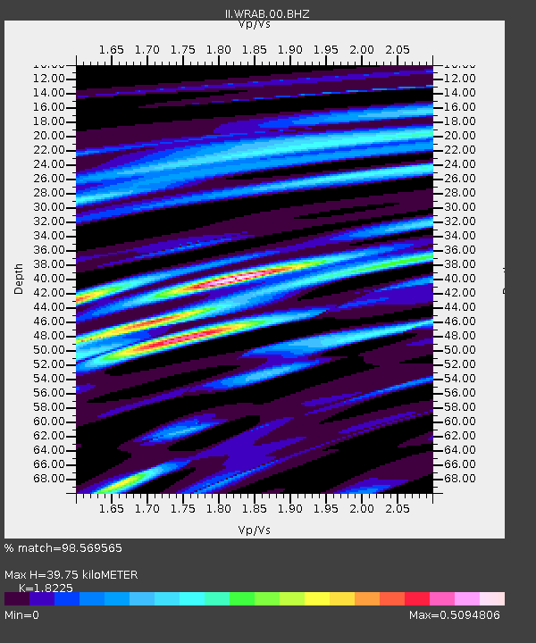
WRAB Tennant Creek, NT, Australia - Earthquake Result Viewer
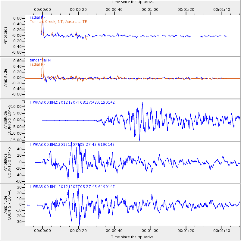
Earthquake location: Off East Coast Of Honshu, Japan
Earthquake latitude/longitude: 37.9/143.9
Earthquake time(UTC): 2012/12/07 (342) 08:18:23 GMT
Earthquake Depth: 31 km
Earthquake Magnitude: 7.2 MB, 7.3 MS, 7.3 MW, 7.3 MW
Earthquake Catalog/Contributor: WHDF/NEIC
Network: II Global Seismograph Network (GSN - IRIS/IDA)
Station: WRAB Tennant Creek, NT, Australia
Lat/Lon: 19.93 S/134.36 E
Elevation: 366 m
Distance: 58.2 deg
Az: 190.624 deg
Baz: 8.919 deg
Ray Param: 0.062935665
Estimated Moho Depth: 39.75 km
Estimated Crust Vp/Vs: 1.82
Assumed Crust Vp: 6.642 km/s
Estimated Crust Vs: 3.644 km/s
Estimated Crust Poisson's Ratio: 0.28
Radial Match: 98.569565 %
Radial Bump: 267
Transverse Match: 95.8347 %
Transverse Bump: 400
SOD ConfigId: 558545
Insert Time: 2013-09-18 01:14:42.494 +0000
GWidth: 2.5
Max Bumps: 400
Tol: 0.001

Signal To Noise

ChannelStoNSTALTA
II:WRAB:00:BHZ:20121207T08:27:43.619014Z108.319841.4121714E-51.3037052E-7
II:WRAB:00:BH1:20121207T08:27:43.619014Z65.1436847.5005837E-61.1513907E-7
II:WRAB:00:BH2:20121207T08:27:43.619014Z15.35096551.3720452E-68.9378425E-8
Arrivals
Ps5.2 SECOND
PpPs16 SECOND
PsPs/PpSs21 SECOND