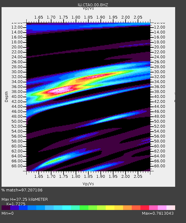
CTAO Charters Towers, Australia - Earthquake Result Viewer
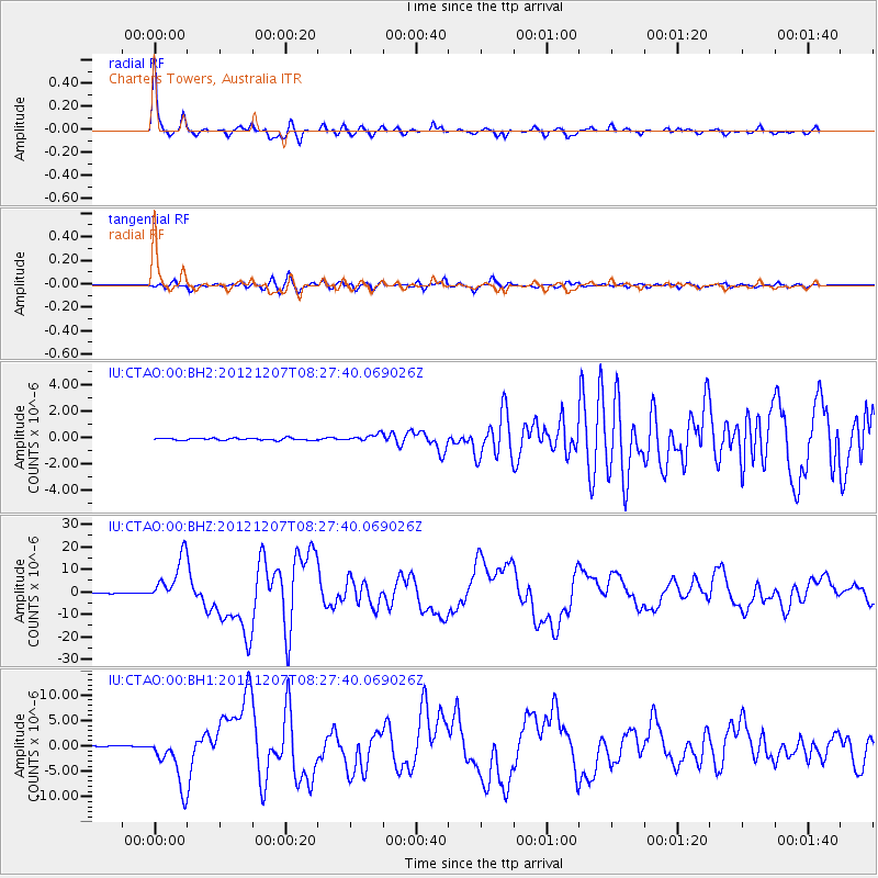
Earthquake location: Off East Coast Of Honshu, Japan
Earthquake latitude/longitude: 37.9/143.9
Earthquake time(UTC): 2012/12/07 (342) 08:18:23 GMT
Earthquake Depth: 31 km
Earthquake Magnitude: 7.2 MB, 7.3 MS, 7.3 MW, 7.3 MW
Earthquake Catalog/Contributor: WHDF/NEIC
Network: IU Global Seismograph Network (GSN - IRIS/USGS)
Station: CTAO Charters Towers, Australia
Lat/Lon: 20.09 S/146.25 E
Elevation: 357 m
Distance: 57.7 deg
Az: 177.436 deg
Baz: 357.842 deg
Ray Param: 0.06326682
Estimated Moho Depth: 37.25 km
Estimated Crust Vp/Vs: 1.73
Assumed Crust Vp: 6.522 km/s
Estimated Crust Vs: 3.775 km/s
Estimated Crust Poisson's Ratio: 0.25
Radial Match: 97.287186 %
Radial Bump: 295
Transverse Match: 87.286285 %
Transverse Bump: 400
SOD ConfigId: 558545
Insert Time: 2013-09-18 01:15:09.869 +0000
GWidth: 2.5
Max Bumps: 400
Tol: 0.001

Signal To Noise

ChannelStoNSTALTA
IU:CTAO:00:BHZ:20121207T08:27:40.069026Z75.437571.0235498E-51.3568172E-7
IU:CTAO:00:BH1:20121207T08:27:40.069026Z60.273335.202808E-68.6320235E-8
IU:CTAO:00:BH2:20121207T08:27:40.069026Z3.27682.61402E-77.977356E-8
Arrivals
Ps4.4 SECOND
PpPs15 SECOND
PsPs/PpSs19 SECOND