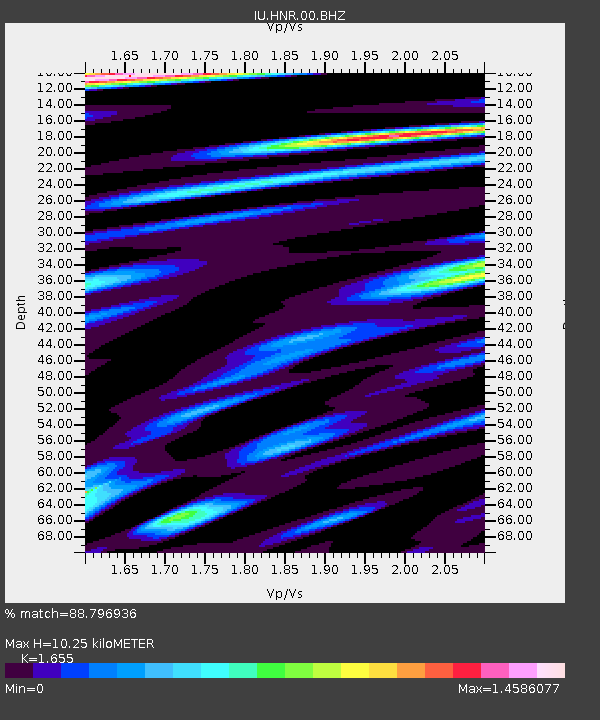
HNR Honiara, Solomon Islands - Earthquake Result Viewer
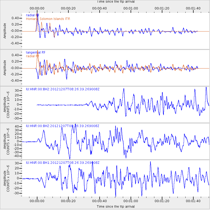
Earthquake location: Off East Coast Of Honshu, Japan
Earthquake latitude/longitude: 37.9/143.9
Earthquake time(UTC): 2012/12/07 (342) 08:18:23 GMT
Earthquake Depth: 31 km
Earthquake Magnitude: 7.2 MB, 7.3 MS, 7.3 MW, 7.3 MW
Earthquake Catalog/Contributor: WHDF/NEIC
Network: IU Global Seismograph Network (GSN - IRIS/USGS)
Station: HNR Honiara, Solomon Islands
Lat/Lon: 9.44 S/159.95 E
Elevation: 100 m
Distance: 49.4 deg
Az: 159.015 deg
Baz: 343.31 deg
Ray Param: 0.06866626
Estimated Moho Depth: 10.25 km
Estimated Crust Vp/Vs: 1.65
Assumed Crust Vp: 6.183 km/s
Estimated Crust Vs: 3.736 km/s
Estimated Crust Poisson's Ratio: 0.21
Radial Match: 88.796936 %
Radial Bump: 400
Transverse Match: 87.45699 %
Transverse Bump: 400
SOD ConfigId: 558545
Insert Time: 2013-09-18 01:15:34.047 +0000
GWidth: 2.5
Max Bumps: 400
Tol: 0.001

Signal To Noise

ChannelStoNSTALTA
IU:HNR:00:BHZ:20121207T08:26:39.269008Z52.2916681.3865984E-52.6516622E-7
IU:HNR:00:BH1:20121207T08:26:39.269008Z20.7662146.3612306E-63.0632597E-7
IU:HNR:00:BH2:20121207T08:26:39.269008Z11.8895523.385993E-62.847873E-7
Arrivals
Ps1.2 SECOND
PpPs4.2 SECOND
PsPs/PpSs5.3 SECOND