You are here: Home > Network List > US - United States National Seismic Network Stations List
> Station AMTX Amarillo, Texas, USA > Earthquake Result Viewer
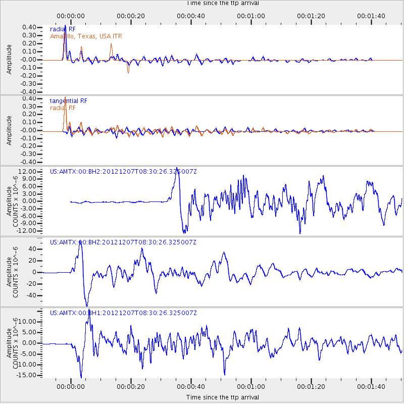
AMTX Amarillo, Texas, USA - Earthquake Result Viewer
*The percent match for this event was below the threshold and hence no stack was calculated.
| Earthquake location: |
Off East Coast Of Honshu, Japan |
| Earthquake latitude/longitude: |
37.9/143.9 |
| Earthquake time(UTC): |
2012/12/07 (342) 08:18:23 GMT |
| Earthquake Depth: |
31 km |
| Earthquake Magnitude: |
7.2 MB, 7.3 MS, 7.3 MW, 7.3 MW |
| Earthquake Catalog/Contributor: |
WHDF/NEIC |
|
| Network: |
US United States National Seismic Network |
| Station: |
AMTX Amarillo, Texas, USA |
| Lat/Lon: |
34.53 N/101.41 W |
| Elevation: |
1010 m |
|
| Distance: |
85.8 deg |
| Az: |
48.799 deg |
| Baz: |
313.86 deg |
| Ray Param: |
$rayparam |
*The percent match for this event was below the threshold and hence was not used in the summary stack. |
|
| Radial Match: |
98.50601 % |
| Radial Bump: |
390 |
| Transverse Match: |
91.69902 % |
| Transverse Bump: |
400 |
| SOD ConfigId: |
558545 |
| Insert Time: |
2013-09-18 01:17:33.753 +0000 |
| GWidth: |
2.5 |
| Max Bumps: |
400 |
| Tol: |
0.001 |
|
Signal To Noise
| Channel | StoN | STA | LTA |
| US:AMTX:00:BHZ:20121207T08:30:26.325007Z | 134.97702 | 2.8376133E-5 | 2.1022936E-7 |
| US:AMTX:00:BH1:20121207T08:30:26.325007Z | 45.54482 | 6.3062853E-6 | 1.3846329E-7 |
| US:AMTX:00:BH2:20121207T08:30:26.325007Z | 40.4039 | 6.808743E-6 | 1.6851698E-7 |
| Arrivals |
| Ps | |
| PpPs | |
| PsPs/PpSs | |


