You are here: Home > Network List > TA - USArray Transportable Network (new EarthScope stations) Stations List
> Station H17A Grant Village (NPS), Yellowstone Nt. Park, WY, USA > Earthquake Result Viewer
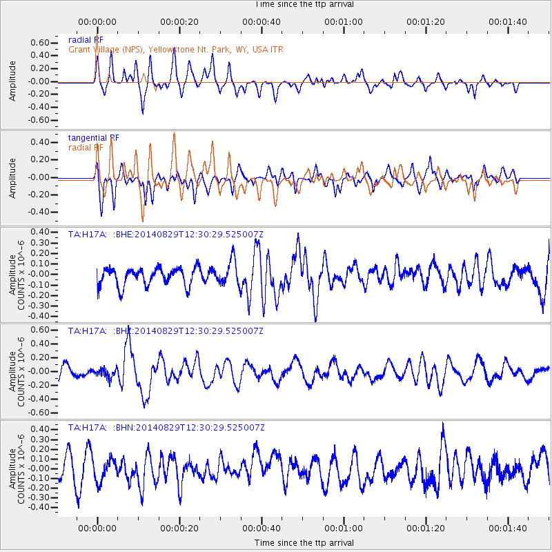
H17A Grant Village (NPS), Yellowstone Nt. Park, WY, USA - Earthquake Result Viewer
*The percent match for this event was below the threshold and hence no stack was calculated.
| Earthquake location: |
Iceland |
| Earthquake latitude/longitude: |
64.7/-17.3 |
| Earthquake time(UTC): |
2014/08/29 (241) 12:21:49 GMT |
| Earthquake Depth: |
10 km |
| Earthquake Magnitude: |
5.3 MW, 5.2 mb, 5.4 Mww |
| Earthquake Catalog/Contributor: |
ISC/ISC |
|
| Network: |
TA USArray Transportable Network (new EarthScope stations) |
| Station: |
H17A Grant Village (NPS), Yellowstone Nt. Park, WY, USA |
| Lat/Lon: |
44.40 N/110.58 W |
| Elevation: |
2400 m |
|
| Distance: |
52.2 deg |
| Az: |
295.137 deg |
| Baz: |
32.833 deg |
| Ray Param: |
$rayparam |
*The percent match for this event was below the threshold and hence was not used in the summary stack. |
|
| Radial Match: |
68.77556 % |
| Radial Bump: |
400 |
| Transverse Match: |
62.595425 % |
| Transverse Bump: |
400 |
| SOD ConfigId: |
3390531 |
| Insert Time: |
2019-04-13 17:09:39.988 +0000 |
| GWidth: |
2.5 |
| Max Bumps: |
400 |
| Tol: |
0.001 |
|
Signal To Noise
| Channel | StoN | STA | LTA |
| TA:H17A: :BHZ:20140829T12:30:29.525007Z | 0.601144 | 6.163905E-8 | 1.0253625E-7 |
| TA:H17A: :BHN:20140829T12:30:29.525007Z | 0.8947661 | 1.0834094E-7 | 1.2108298E-7 |
| TA:H17A: :BHE:20140829T12:30:29.525007Z | 1.4571124 | 1.230241E-7 | 8.443006E-8 |
| Arrivals |
| Ps | |
| PpPs | |
| PsPs/PpSs | |


