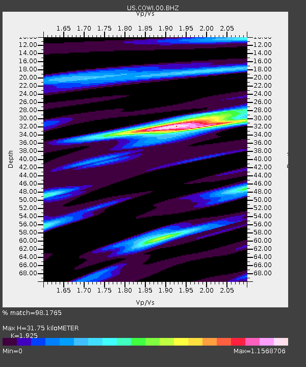
COWI Conover, Wisconsin, USA - Earthquake Result Viewer

Earthquake location: Off East Coast Of Honshu, Japan
Earthquake latitude/longitude: 37.9/143.9
Earthquake time(UTC): 2012/12/07 (342) 08:18:23 GMT
Earthquake Depth: 31 km
Earthquake Magnitude: 7.2 MB, 7.3 MS, 7.3 MW, 7.3 MW
Earthquake Catalog/Contributor: WHDF/NEIC
Network: US United States National Seismic Network
Station: COWI Conover, Wisconsin, USA
Lat/Lon: 46.10 N/89.14 W
Elevation: 523 m
Distance: 83.8 deg
Az: 34.031 deg
Baz: 320.48 deg
Ray Param: 0.045914944
Estimated Moho Depth: 31.75 km
Estimated Crust Vp/Vs: 1.92
Assumed Crust Vp: 6.467 km/s
Estimated Crust Vs: 3.359 km/s
Estimated Crust Poisson's Ratio: 0.32
Radial Match: 98.1765 %
Radial Bump: 400
Transverse Match: 90.72888 %
Transverse Bump: 400
SOD ConfigId: 558545
Insert Time: 2013-09-18 01:18:05.300 +0000
GWidth: 2.5
Max Bumps: 400
Tol: 0.001

Signal To Noise

ChannelStoNSTALTA
US:COWI:00:BHZ:20121207T08:30:17.999019Z83.01621.9772506E-52.3817647E-7
US:COWI:00:BH1:20121207T08:30:17.999019Z27.0875875.4541983E-62.0135415E-7
US:COWI:00:BH2:20121207T08:30:17.999019Z31.9947095.07038E-61.5847559E-7
Arrivals
Ps4.6 SECOND
PpPs14 SECOND
PsPs/PpSs19 SECOND