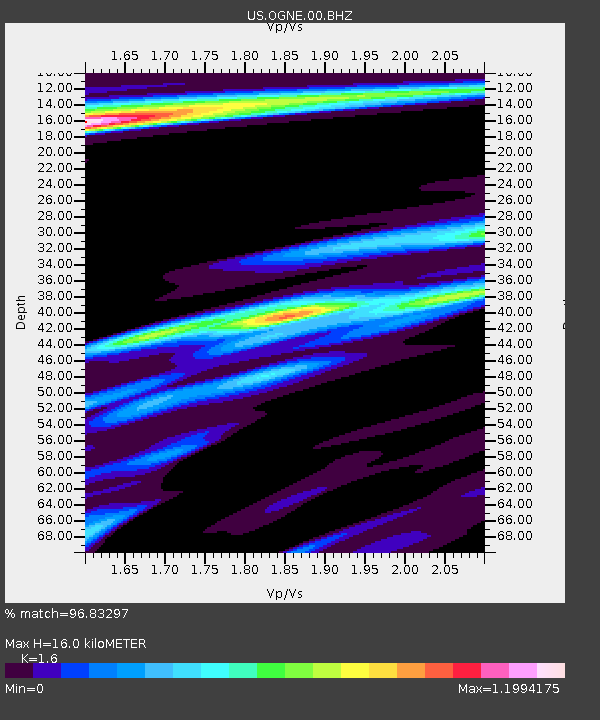
OGNE Ogallala, Nebraska, USA - Earthquake Result Viewer
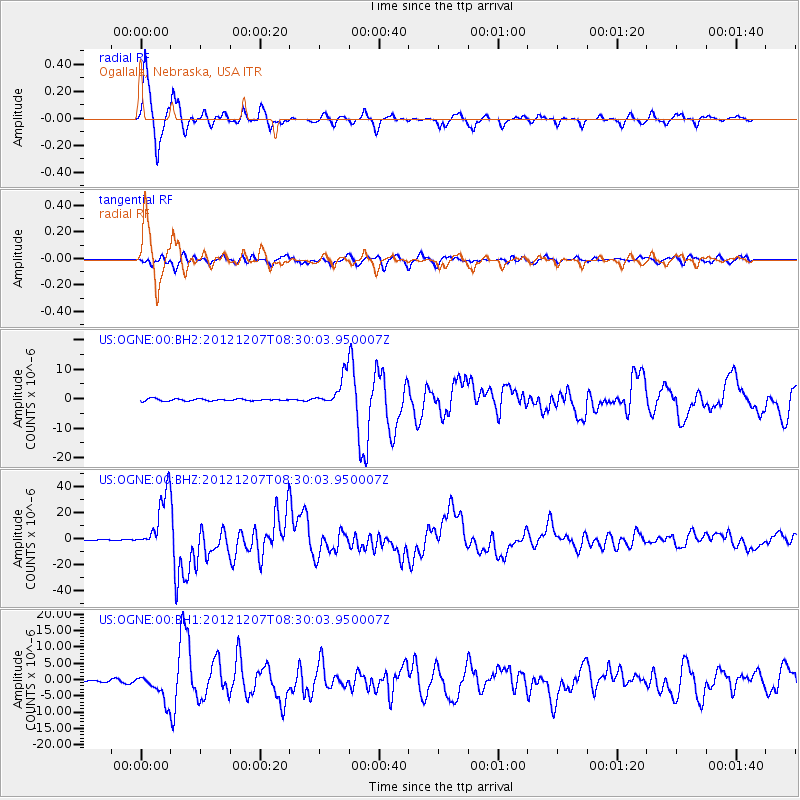
Earthquake location: Off East Coast Of Honshu, Japan
Earthquake latitude/longitude: 37.9/143.9
Earthquake time(UTC): 2012/12/07 (342) 08:18:23 GMT
Earthquake Depth: 31 km
Earthquake Magnitude: 7.2 MB, 7.3 MS, 7.3 MW, 7.3 MW
Earthquake Catalog/Contributor: WHDF/NEIC
Network: US United States National Seismic Network
Station: OGNE Ogallala, Nebraska, USA
Lat/Lon: 40.95 N/102.03 W
Elevation: 0.0 m
Distance: 81.1 deg
Az: 44.461 deg
Baz: 312.983 deg
Ray Param: 0.04780729
Estimated Moho Depth: 16.0 km
Estimated Crust Vp/Vs: 1.60
Assumed Crust Vp: 6.483 km/s
Estimated Crust Vs: 4.052 km/s
Estimated Crust Poisson's Ratio: 0.18
Radial Match: 96.83297 %
Radial Bump: 307
Transverse Match: 86.87183 %
Transverse Bump: 400
SOD ConfigId: 558545
Insert Time: 2013-09-18 01:20:07.628 +0000
GWidth: 2.5
Max Bumps: 400
Tol: 0.001

Signal To Noise

ChannelStoNSTALTA
US:OGNE:00:BHZ:20121207T08:30:03.950007Z113.31922.2365879E-51.9737061E-7
US:OGNE:00:BH1:20121207T08:30:03.950007Z11.1279794.2224206E-63.794418E-7
US:OGNE:00:BH2:20121207T08:30:03.950007Z15.1385765.2859327E-63.4916977E-7
Arrivals
Ps1.5 SECOND
PpPs6.2 SECOND
PsPs/PpSs7.7 SECOND