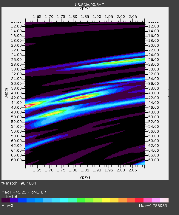
SCIA State Center, Iowa, USA - Earthquake Result Viewer

Earthquake location: Off East Coast Of Honshu, Japan
Earthquake latitude/longitude: 37.9/143.9
Earthquake time(UTC): 2012/12/07 (342) 08:18:23 GMT
Earthquake Depth: 31 km
Earthquake Magnitude: 7.2 MB, 7.3 MS, 7.3 MW, 7.3 MW
Earthquake Catalog/Contributor: WHDF/NEIC
Network: US United States National Seismic Network
Station: SCIA State Center, Iowa, USA
Lat/Lon: 41.91 N/93.22 W
Elevation: 312 m
Distance: 85.0 deg
Az: 39.018 deg
Baz: 318.142 deg
Ray Param: 0.045022015
Estimated Moho Depth: 45.25 km
Estimated Crust Vp/Vs: 1.60
Assumed Crust Vp: 6.498 km/s
Estimated Crust Vs: 4.061 km/s
Estimated Crust Poisson's Ratio: 0.18
Radial Match: 98.4664 %
Radial Bump: 225
Transverse Match: 90.30748 %
Transverse Bump: 400
SOD ConfigId: 558545
Insert Time: 2013-09-18 01:20:19.685 +0000
GWidth: 2.5
Max Bumps: 400
Tol: 0.001

Signal To Noise

ChannelStoNSTALTA
US:SCIA:00:BHZ:20121207T08:30:24.349971Z117.231622.30123E-51.9629773E-7
US:SCIA:00:BH1:20121207T08:30:24.349971Z21.4029526.377918E-62.9799244E-7
US:SCIA:00:BH2:20121207T08:30:24.349971Z20.4933936.0085763E-62.9319577E-7
Arrivals
Ps4.3 SECOND
PpPs18 SECOND
PsPs/PpSs22 SECOND