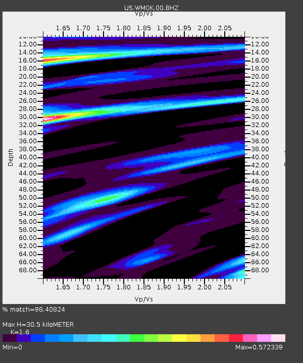
WMOK Wichita Mountains, Oklahoma, USA - Earthquake Result Viewer
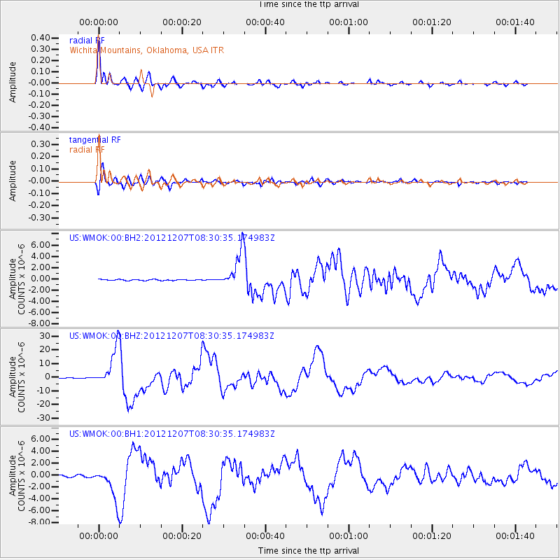
Earthquake location: Off East Coast Of Honshu, Japan
Earthquake latitude/longitude: 37.9/143.9
Earthquake time(UTC): 2012/12/07 (342) 08:18:23 GMT
Earthquake Depth: 31 km
Earthquake Magnitude: 7.2 MB, 7.3 MS, 7.3 MW, 7.3 MW
Earthquake Catalog/Contributor: WHDF/NEIC
Network: US United States National Seismic Network
Station: WMOK Wichita Mountains, Oklahoma, USA
Lat/Lon: 34.74 N/98.78 W
Elevation: 486 m
Distance: 87.2 deg
Az: 47.128 deg
Baz: 315.245 deg
Ray Param: 0.043435574
Estimated Moho Depth: 30.5 km
Estimated Crust Vp/Vs: 1.60
Assumed Crust Vp: 6.315 km/s
Estimated Crust Vs: 3.947 km/s
Estimated Crust Poisson's Ratio: 0.18
Radial Match: 98.40824 %
Radial Bump: 400
Transverse Match: 94.693504 %
Transverse Bump: 400
SOD ConfigId: 558545
Insert Time: 2013-09-18 01:20:39.809 +0000
GWidth: 2.5
Max Bumps: 400
Tol: 0.001

Signal To Noise

ChannelStoNSTALTA
US:WMOK:00:BHZ:20121207T08:30:35.174983Z81.279541.4459167E-51.778943E-7
US:WMOK:00:BH1:20121207T08:30:35.174983Z18.5031452.82174E-61.5250056E-7
US:WMOK:00:BH2:20121207T08:30:35.174983Z35.1907463.3019655E-69.383051E-8
Arrivals
Ps3.0 SECOND
PpPs12 SECOND
PsPs/PpSs15 SECOND