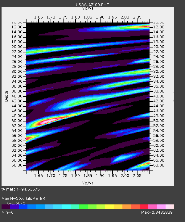
WUAZ Wupatki, Arizona, USA - Earthquake Result Viewer
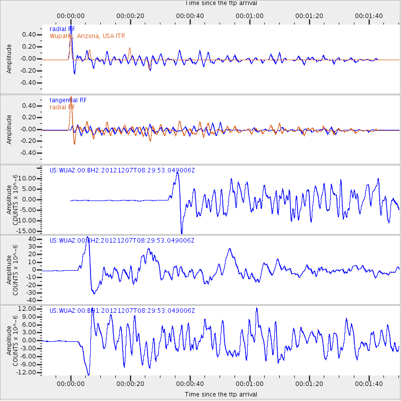
Earthquake location: Off East Coast Of Honshu, Japan
Earthquake latitude/longitude: 37.9/143.9
Earthquake time(UTC): 2012/12/07 (342) 08:18:23 GMT
Earthquake Depth: 31 km
Earthquake Magnitude: 7.2 MB, 7.3 MS, 7.3 MW, 7.3 MW
Earthquake Catalog/Contributor: WHDF/NEIC
Network: US United States National Seismic Network
Station: WUAZ Wupatki, Arizona, USA
Lat/Lon: 35.52 N/111.37 W
Elevation: 1592 m
Distance: 79.0 deg
Az: 53.498 deg
Baz: 308.776 deg
Ray Param: 0.049194198
Estimated Moho Depth: 50.0 km
Estimated Crust Vp/Vs: 1.69
Assumed Crust Vp: 6.207 km/s
Estimated Crust Vs: 3.678 km/s
Estimated Crust Poisson's Ratio: 0.23
Radial Match: 94.53575 %
Radial Bump: 400
Transverse Match: 87.30398 %
Transverse Bump: 400
SOD ConfigId: 558545
Insert Time: 2013-09-18 01:20:46.828 +0000
GWidth: 2.5
Max Bumps: 400
Tol: 0.001

Signal To Noise

ChannelStoNSTALTA
US:WUAZ:00:BHZ:20121207T08:29:53.049006Z90.5238349.578991E-61.05817335E-7
US:WUAZ:00:BH1:20121207T08:29:53.049006Z23.5015432.6310565E-61.119525E-7
US:WUAZ:00:BH2:20121207T08:29:53.049006Z25.5422572.7905119E-61.0925079E-7
Arrivals
Ps5.7 SECOND
PpPs21 SECOND
PsPs/PpSs27 SECOND