You are here: Home > Network List > TA - USArray Transportable Network (new EarthScope stations) Stations List
> Station Z41A Richland Creek Farm, El Dorado, AR, USA > Earthquake Result Viewer
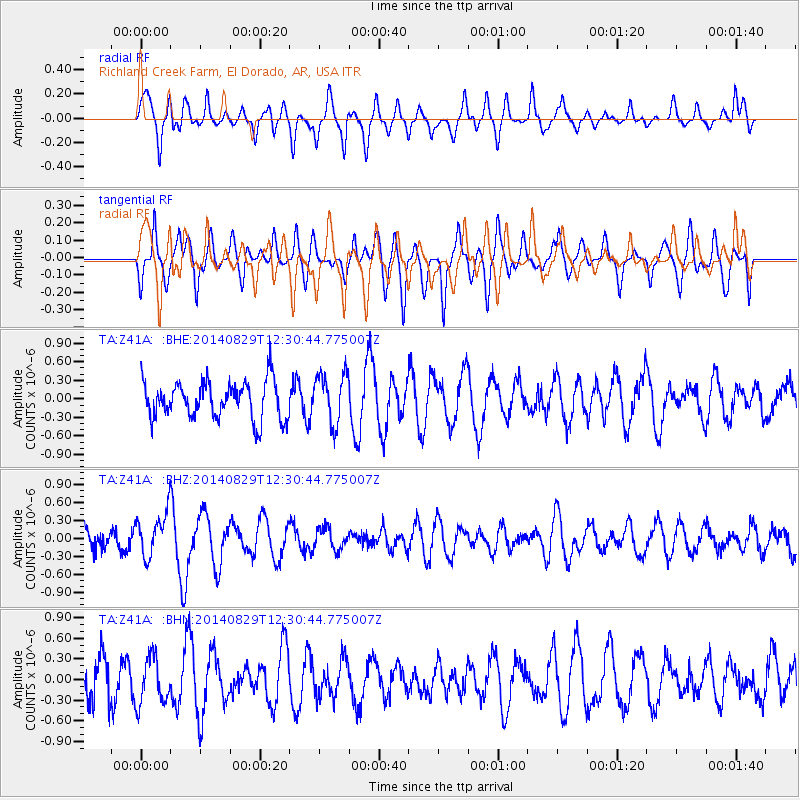
Z41A Richland Creek Farm, El Dorado, AR, USA - Earthquake Result Viewer
*The percent match for this event was below the threshold and hence no stack was calculated.
| Earthquake location: |
Iceland |
| Earthquake latitude/longitude: |
64.7/-17.3 |
| Earthquake time(UTC): |
2014/08/29 (241) 12:21:49 GMT |
| Earthquake Depth: |
10 km |
| Earthquake Magnitude: |
5.3 MW, 5.2 mb, 5.4 Mww |
| Earthquake Catalog/Contributor: |
ISC/ISC |
|
| Network: |
TA USArray Transportable Network (new EarthScope stations) |
| Station: |
Z41A Richland Creek Farm, El Dorado, AR, USA |
| Lat/Lon: |
33.26 N/92.80 W |
| Elevation: |
62 m |
|
| Distance: |
54.3 deg |
| Az: |
273.13 deg |
| Baz: |
30.774 deg |
| Ray Param: |
$rayparam |
*The percent match for this event was below the threshold and hence was not used in the summary stack. |
|
| Radial Match: |
64.547485 % |
| Radial Bump: |
303 |
| Transverse Match: |
54.6512 % |
| Transverse Bump: |
378 |
| SOD ConfigId: |
3390531 |
| Insert Time: |
2019-04-13 17:10:35.244 +0000 |
| GWidth: |
2.5 |
| Max Bumps: |
400 |
| Tol: |
0.001 |
|
Signal To Noise
| Channel | StoN | STA | LTA |
| TA:Z41A: :BHZ:20140829T12:30:44.775007Z | 2.3316638 | 3.8162725E-7 | 1.6367166E-7 |
| TA:Z41A: :BHN:20140829T12:30:44.775007Z | 0.9600069 | 3.3817795E-7 | 3.5226617E-7 |
| TA:Z41A: :BHE:20140829T12:30:44.775007Z | 1.3571712 | 4.0899798E-7 | 3.0136064E-7 |
| Arrivals |
| Ps | |
| PpPs | |
| PsPs/PpSs | |


