You are here: Home > Network List > II - Global Seismograph Network (GSN - IRIS/IDA) Stations List
> Station KAPI Kappang, Sulawesi, Indonesia > Earthquake Result Viewer
KAPI Kappang, Sulawesi, Indonesia - Earthquake Result Viewer
| Earthquake location: |
North Island, New Zealand |
| Earthquake latitude/longitude: |
-38.4/176.1 |
| Earthquake time(UTC): |
2012/12/07 (342) 18:19:06 GMT |
| Earthquake Depth: |
163 km |
| Earthquake Magnitude: |
5.7 MB, 6.3 MW, 6.4 MW |
| Earthquake Catalog/Contributor: |
WHDF/NEIC |
|
| Network: |
II Global Seismograph Network (GSN - IRIS/IDA) |
| Station: |
KAPI Kappang, Sulawesi, Indonesia |
| Lat/Lon: |
5.01 S/119.75 E |
| Elevation: |
300 m |
|
| Distance: |
60.8 deg |
| Az: |
288.278 deg |
| Baz: |
131.529 deg |
| Ray Param: |
0.060786527 |
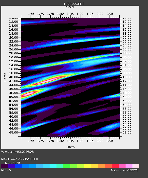
| Estimated Moho Depth: |
42.25 km |
| Estimated Crust Vp/Vs: |
1.72 |
| Assumed Crust Vp: |
6.343 km/s |
| Estimated Crust Vs: |
3.693 km/s |
| Estimated Crust Poisson's Ratio: |
0.24 |
|
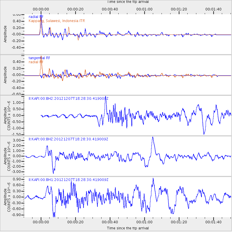
| Radial Match: |
93.219505 % |
| Radial Bump: |
400 |
| Transverse Match: |
87.48578 % |
| Transverse Bump: |
400 |
| SOD ConfigId: |
558545 |
| Insert Time: |
2013-09-18 01:30:33.743 +0000 |
| GWidth: |
2.5 |
| Max Bumps: |
400 |
| Tol: |
0.001 |
|
Signal To Noise
| Channel | StoN | STA | LTA |
| II:KAPI:00:BHZ:20121207T18:28:30.419009Z | 7.6090245 | 8.424396E-7 | 1.1071585E-7 |
| II:KAPI:00:BH1:20121207T18:28:30.419009Z | 5.730204 | 2.5008953E-7 | 4.3644086E-8 |
| II:KAPI:00:BH2:20121207T18:28:30.419009Z | 4.048785 | 3.1625555E-7 | 7.811121E-8 |
| Arrivals |
| Ps | 5.0 SECOND |
| PpPs | 17 SECOND |
| PsPs/PpSs | 22 SECOND |


