You are here: Home > Network List > IU - Global Seismograph Network (GSN - IRIS/USGS) Stations List
> Station CTAO Charters Towers, Australia > Earthquake Result Viewer
CTAO Charters Towers, Australia - Earthquake Result Viewer

| Earthquake location: |
North Island, New Zealand |
| Earthquake latitude/longitude: |
-38.4/176.1 |
| Earthquake time(UTC): |
2012/12/07 (342) 18:19:06 GMT |
| Earthquake Depth: |
163 km |
| Earthquake Magnitude: |
5.7 MB, 6.3 MW, 6.4 MW |
| Earthquake Catalog/Contributor: |
WHDF/NEIC |
|
| Network: |
IU Global Seismograph Network (GSN - IRIS/USGS) |
| Station: |
CTAO Charters Towers, Australia |
| Lat/Lon: |
20.09 S/146.25 E |
| Elevation: |
357 m |
|
| Distance: |
31.6 deg |
| Az: |
296.855 deg |
| Baz: |
131.797 deg |
| Ray Param: |
0.07854176 |
| Estimated Moho Depth: |
11.5 km |
| Estimated Crust Vp/Vs: |
2.10 |
| Assumed Crust Vp: |
6.522 km/s |
| Estimated Crust Vs: |
3.109 km/s |
| Estimated Crust Poisson's Ratio: |
0.35 |
|
| Radial Match: |
95.84179 % |
| Radial Bump: |
278 |
| Transverse Match: |
81.68094 % |
| Transverse Bump: |
400 |
| SOD ConfigId: |
558545 |
| Insert Time: |
2013-09-18 01:30:59.244 +0000 |
| GWidth: |
2.5 |
| Max Bumps: |
400 |
| Tol: |
0.001 |
|
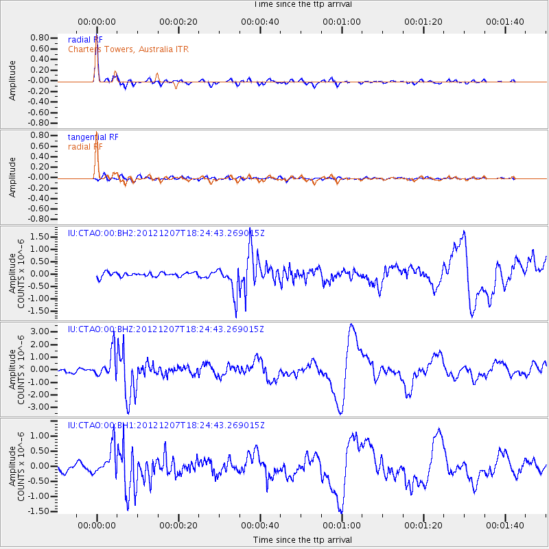
Signal To Noise
| Channel | StoN | STA | LTA |
| IU:CTAO:00:BHZ:20121207T18:24:43.269015Z | 6.6796813 | 1.0655107E-6 | 1.5951521E-7 |
| IU:CTAO:00:BH1:20121207T18:24:43.269015Z | 4.2954845 | 4.832571E-7 | 1.1250351E-7 |
| IU:CTAO:00:BH2:20121207T18:24:43.269015Z | 6.539503 | 5.687024E-7 | 8.696416E-8 |
| Arrivals |
| Ps | 2.1 SECOND |
| PpPs | 5.1 SECOND |
| PsPs/PpSs | 7.2 SECOND |


