You are here: Home > Network List > IU - Global Seismograph Network (GSN - IRIS/USGS) Stations List
> Station HNR Honiara, Solomon Islands > Earthquake Result Viewer
HNR Honiara, Solomon Islands - Earthquake Result Viewer
| Earthquake location: |
North Island, New Zealand |
| Earthquake latitude/longitude: |
-38.4/176.1 |
| Earthquake time(UTC): |
2012/12/07 (342) 18:19:06 GMT |
| Earthquake Depth: |
163 km |
| Earthquake Magnitude: |
5.7 MB, 6.3 MW, 6.4 MW |
| Earthquake Catalog/Contributor: |
WHDF/NEIC |
|
| Network: |
IU Global Seismograph Network (GSN - IRIS/USGS) |
| Station: |
HNR Honiara, Solomon Islands |
| Lat/Lon: |
9.44 S/159.95 E |
| Elevation: |
100 m |
|
| Distance: |
32.3 deg |
| Az: |
329.156 deg |
| Baz: |
155.912 deg |
| Ray Param: |
0.0782254 |
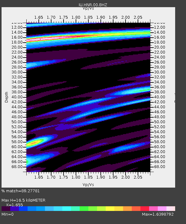
| Estimated Moho Depth: |
16.5 km |
| Estimated Crust Vp/Vs: |
1.65 |
| Assumed Crust Vp: |
6.183 km/s |
| Estimated Crust Vs: |
3.736 km/s |
| Estimated Crust Poisson's Ratio: |
0.21 |
|
| Radial Match: |
89.27781 % |
| Radial Bump: |
400 |
| Transverse Match: |
90.93195 % |
| Transverse Bump: |
400 |
| SOD ConfigId: |
558545 |
| Insert Time: |
2013-09-18 01:31:18.202 +0000 |
| GWidth: |
2.5 |
| Max Bumps: |
400 |
| Tol: |
0.001 |
|
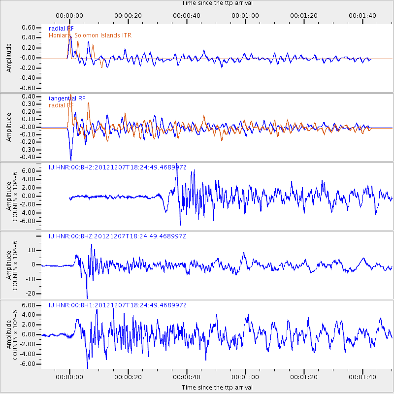
Signal To Noise
| Channel | StoN | STA | LTA |
| IU:HNR:00:BHZ:20121207T18:24:49.468997Z | 17.774763 | 3.5392375E-6 | 1.9911587E-7 |
| IU:HNR:00:BH1:20121207T18:24:49.468997Z | 10.606405 | 1.5918797E-6 | 1.5008663E-7 |
| IU:HNR:00:BH2:20121207T18:24:49.468997Z | 9.059955 | 1.6200617E-6 | 1.7881565E-7 |
| Arrivals |
| Ps | 1.9 SECOND |
| PpPs | 6.6 SECOND |
| PsPs/PpSs | 8.4 SECOND |


