You are here: Home > Network List > IU - Global Seismograph Network (GSN - IRIS/USGS) Stations List
> Station PMG Port Moresby, New Guinea > Earthquake Result Viewer
PMG Port Moresby, New Guinea - Earthquake Result Viewer
| Earthquake location: |
North Island, New Zealand |
| Earthquake latitude/longitude: |
-38.4/176.1 |
| Earthquake time(UTC): |
2012/12/07 (342) 18:19:06 GMT |
| Earthquake Depth: |
163 km |
| Earthquake Magnitude: |
5.7 MB, 6.3 MW, 6.4 MW |
| Earthquake Catalog/Contributor: |
WHDF/NEIC |
|
| Network: |
IU Global Seismograph Network (GSN - IRIS/USGS) |
| Station: |
PMG Port Moresby, New Guinea |
| Lat/Lon: |
9.40 S/147.16 E |
| Elevation: |
90 m |
|
| Distance: |
38.8 deg |
| Az: |
310.484 deg |
| Baz: |
142.742 deg |
| Ray Param: |
0.07473442 |
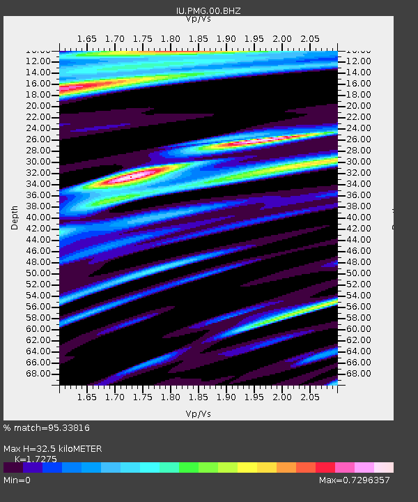
| Estimated Moho Depth: |
32.5 km |
| Estimated Crust Vp/Vs: |
1.73 |
| Assumed Crust Vp: |
6.122 km/s |
| Estimated Crust Vs: |
3.544 km/s |
| Estimated Crust Poisson's Ratio: |
0.25 |
|
| Radial Match: |
95.33816 % |
| Radial Bump: |
400 |
| Transverse Match: |
83.33536 % |
| Transverse Bump: |
400 |
| SOD ConfigId: |
558545 |
| Insert Time: |
2013-09-18 01:31:39.461 +0000 |
| GWidth: |
2.5 |
| Max Bumps: |
400 |
| Tol: |
0.001 |
|

Signal To Noise
| Channel | StoN | STA | LTA |
| IU:PMG:00:BHZ:20121207T18:25:45.069003Z | 15.798368 | 1.68938E-6 | 1.0693383E-7 |
| IU:PMG:00:BH1:20121207T18:25:45.069003Z | 6.3052964 | 6.962802E-7 | 1.10427834E-7 |
| IU:PMG:00:BH2:20121207T18:25:45.069003Z | 5.4664288 | 4.830483E-7 | 8.836635E-8 |
| Arrivals |
| Ps | 4.1 SECOND |
| PpPs | 14 SECOND |
| PsPs/PpSs | 18 SECOND |


