You are here: Home > Network List > IU - Global Seismograph Network (GSN - IRIS/USGS) Stations List
> Station HNR Honiara, Solomon Islands > Earthquake Result Viewer
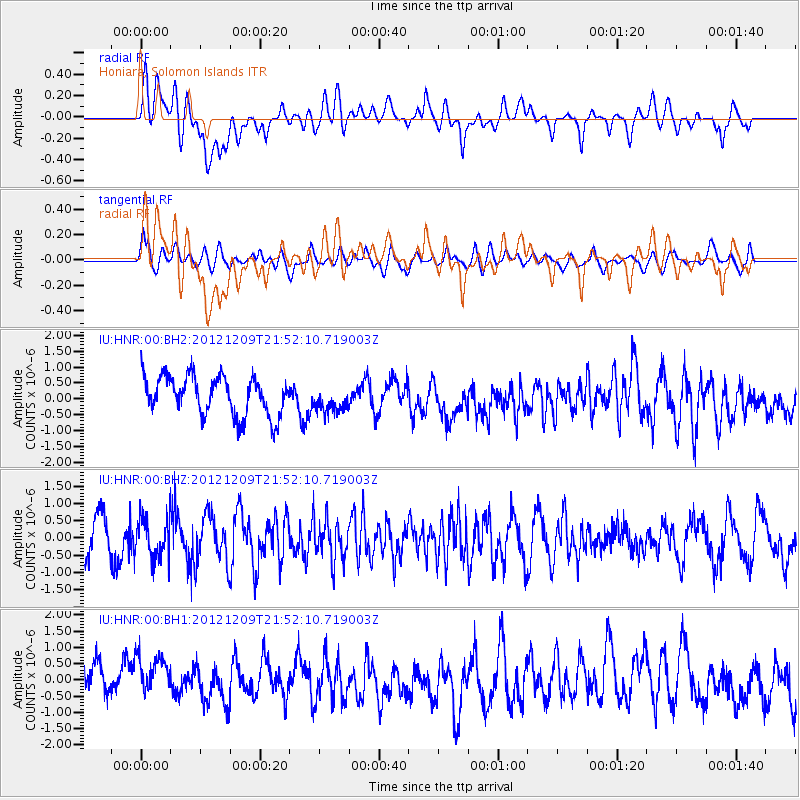
HNR Honiara, Solomon Islands - Earthquake Result Viewer
*The percent match for this event was below the threshold and hence no stack was calculated.
| Earthquake location: |
Mindanao, Philippines |
| Earthquake latitude/longitude: |
6.7/126.2 |
| Earthquake time(UTC): |
2012/12/09 (344) 21:45:35 GMT |
| Earthquake Depth: |
63 km |
| Earthquake Magnitude: |
5.6 MW, 5.3 MB, 5.5 MW |
| Earthquake Catalog/Contributor: |
WHDF/NEIC |
|
| Network: |
IU Global Seismograph Network (GSN - IRIS/USGS) |
| Station: |
HNR Honiara, Solomon Islands |
| Lat/Lon: |
9.44 S/159.95 E |
| Elevation: |
100 m |
|
| Distance: |
37.3 deg |
| Az: |
115.094 deg |
| Baz: |
294.261 deg |
| Ray Param: |
$rayparam |
*The percent match for this event was below the threshold and hence was not used in the summary stack. |
|
| Radial Match: |
51.194542 % |
| Radial Bump: |
400 |
| Transverse Match: |
62.787373 % |
| Transverse Bump: |
400 |
| SOD ConfigId: |
558545 |
| Insert Time: |
2013-09-18 01:40:52.071 +0000 |
| GWidth: |
2.5 |
| Max Bumps: |
400 |
| Tol: |
0.001 |
|
Signal To Noise
| Channel | StoN | STA | LTA |
| IU:HNR:00:BHZ:20121209T21:52:10.719003Z | 0.8559146 | 5.7363144E-7 | 6.701971E-7 |
| IU:HNR:00:BH1:20121209T21:52:10.719003Z | 1.7768614 | 7.495666E-7 | 4.2184865E-7 |
| IU:HNR:00:BH2:20121209T21:52:10.719003Z | 0.67629623 | 4.171325E-7 | 6.1678963E-7 |
| Arrivals |
| Ps | |
| PpPs | |
| PsPs/PpSs | |


