You are here: Home > Network List > IU - Global Seismograph Network (GSN - IRIS/USGS) Stations List
> Station PMG Port Moresby, New Guinea > Earthquake Result Viewer
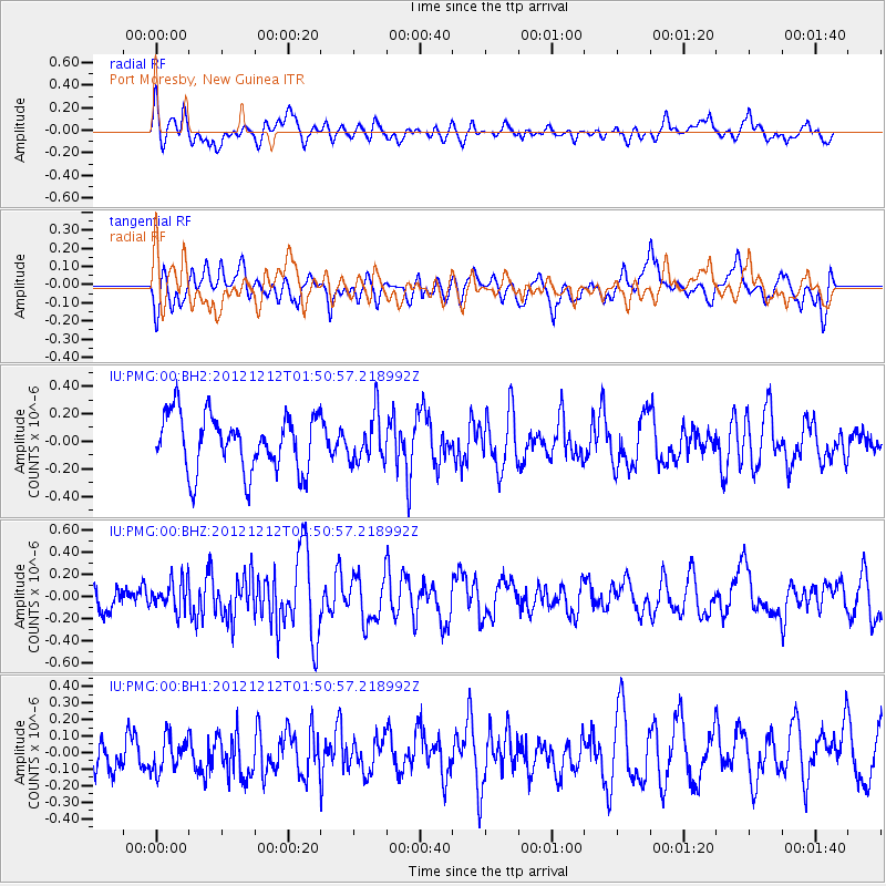
PMG Port Moresby, New Guinea - Earthquake Result Viewer
*The percent match for this event was below the threshold and hence no stack was calculated.
| Earthquake location: |
Fiji Islands Region |
| Earthquake latitude/longitude: |
-19.6/-176.3 |
| Earthquake time(UTC): |
2012/12/12 (347) 01:44:20 GMT |
| Earthquake Depth: |
10 km |
| Earthquake Magnitude: |
5.5 MW |
| Earthquake Catalog/Contributor: |
NEIC PDE/NEIC PDE-W |
|
| Network: |
IU Global Seismograph Network (GSN - IRIS/USGS) |
| Station: |
PMG Port Moresby, New Guinea |
| Lat/Lon: |
9.40 S/147.16 E |
| Elevation: |
90 m |
|
| Distance: |
36.7 deg |
| Az: |
280.658 deg |
| Baz: |
110.081 deg |
| Ray Param: |
$rayparam |
*The percent match for this event was below the threshold and hence was not used in the summary stack. |
|
| Radial Match: |
59.924103 % |
| Radial Bump: |
400 |
| Transverse Match: |
59.450493 % |
| Transverse Bump: |
400 |
| SOD ConfigId: |
558545 |
| Insert Time: |
2013-09-18 01:48:43.402 +0000 |
| GWidth: |
2.5 |
| Max Bumps: |
400 |
| Tol: |
0.001 |
|
Signal To Noise
| Channel | StoN | STA | LTA |
| IU:PMG:00:BHZ:20121212T01:50:57.218992Z | 0.8941535 | 1.3723809E-7 | 1.5348382E-7 |
| IU:PMG:00:BH1:20121212T01:50:57.218992Z | 0.8788173 | 1.2089696E-7 | 1.3756778E-7 |
| IU:PMG:00:BH2:20121212T01:50:57.218992Z | 0.8253662 | 1.682919E-7 | 2.0389967E-7 |
| Arrivals |
| Ps | |
| PpPs | |
| PsPs/PpSs | |


