You are here: Home > Network List > II - Global Seismograph Network (GSN - IRIS/IDA) Stations List
> Station WRAB Tennant Creek, NT, Australia > Earthquake Result Viewer
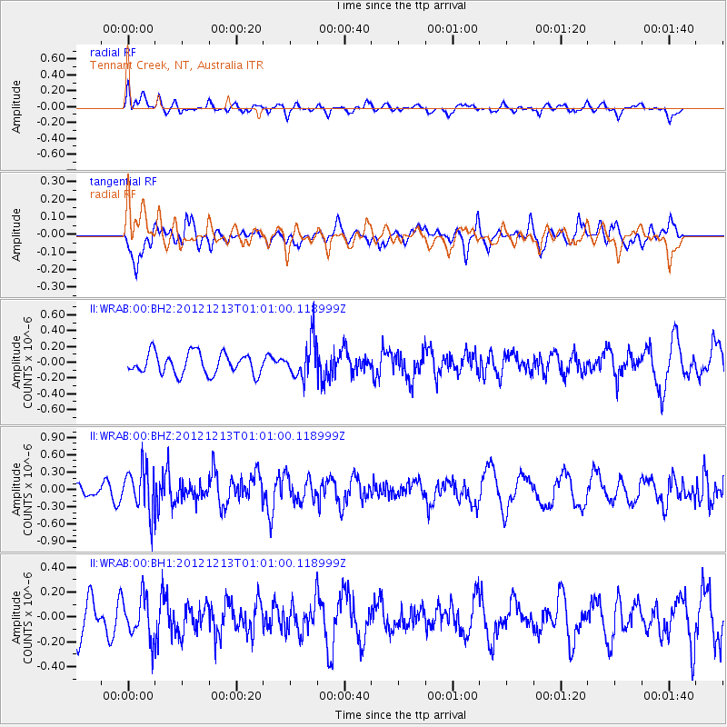
WRAB Tennant Creek, NT, Australia - Earthquake Result Viewer
*The percent match for this event was below the threshold and hence no stack was calculated.
| Earthquake location: |
Kermadec Islands, New Zealand |
| Earthquake latitude/longitude: |
-30.9/-178.4 |
| Earthquake time(UTC): |
2012/12/13 (348) 00:53:28 GMT |
| Earthquake Depth: |
39 km |
| Earthquake Magnitude: |
5.5 MB, 4.9 MS, 5.3 MW, 5.4 MW |
| Earthquake Catalog/Contributor: |
WHDF/NEIC |
|
| Network: |
II Global Seismograph Network (GSN - IRIS/IDA) |
| Station: |
WRAB Tennant Creek, NT, Australia |
| Lat/Lon: |
19.93 S/134.36 E |
| Elevation: |
366 m |
|
| Distance: |
43.8 deg |
| Az: |
272.913 deg |
| Baz: |
114.166 deg |
| Ray Param: |
$rayparam |
*The percent match for this event was below the threshold and hence was not used in the summary stack. |
|
| Radial Match: |
40.738365 % |
| Radial Bump: |
400 |
| Transverse Match: |
55.111355 % |
| Transverse Bump: |
400 |
| SOD ConfigId: |
558545 |
| Insert Time: |
2013-09-18 01:51:20.491 +0000 |
| GWidth: |
2.5 |
| Max Bumps: |
400 |
| Tol: |
0.001 |
|
Signal To Noise
| Channel | StoN | STA | LTA |
| II:WRAB:00:BHZ:20121213T01:01:00.118999Z | 3.65668 | 3.8551318E-7 | 1.054271E-7 |
| II:WRAB:00:BH1:20121213T01:01:00.118999Z | 1.2902119 | 1.6868871E-7 | 1.3074495E-7 |
| II:WRAB:00:BH2:20121213T01:01:00.118999Z | 1.8414365 | 2.4607016E-7 | 1.3362946E-7 |
| Arrivals |
| Ps | |
| PpPs | |
| PsPs/PpSs | |


