You are here: Home > Network List > US - United States National Seismic Network Stations List
> Station DGMT Dagmar, Montana, USA > Earthquake Result Viewer
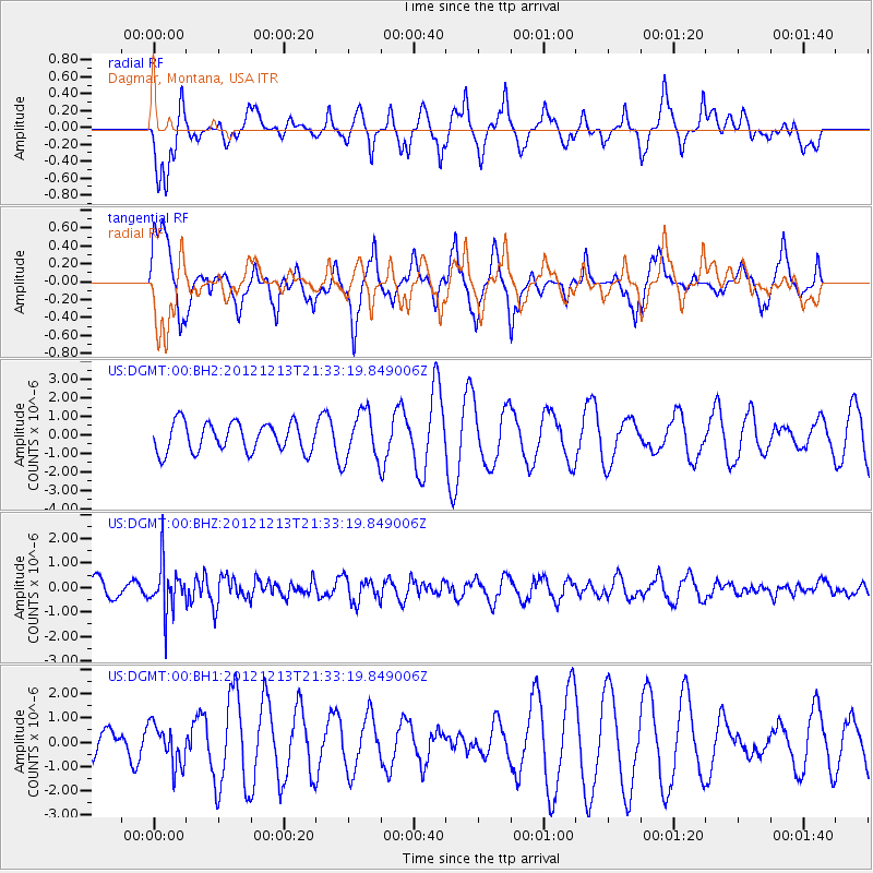
DGMT Dagmar, Montana, USA - Earthquake Result Viewer
*The percent match for this event was below the threshold and hence no stack was calculated.
| Earthquake location: |
El Salvador |
| Earthquake latitude/longitude: |
13.1/-90.0 |
| Earthquake time(UTC): |
2012/12/13 (348) 21:26:39 GMT |
| Earthquake Depth: |
10 km |
| Earthquake Magnitude: |
5.5 MB, 4.9 MS, 5.3 MW, 5.5 MW |
| Earthquake Catalog/Contributor: |
WHDF/NEIC |
|
| Network: |
US United States National Seismic Network |
| Station: |
DGMT Dagmar, Montana, USA |
| Lat/Lon: |
48.47 N/104.20 W |
| Elevation: |
0.0 m |
|
| Distance: |
37.2 deg |
| Az: |
344.311 deg |
| Baz: |
156.675 deg |
| Ray Param: |
$rayparam |
*The percent match for this event was below the threshold and hence was not used in the summary stack. |
|
| Radial Match: |
69.0351 % |
| Radial Bump: |
390 |
| Transverse Match: |
60.1758 % |
| Transverse Bump: |
365 |
| SOD ConfigId: |
558545 |
| Insert Time: |
2013-09-18 01:57:48.852 +0000 |
| GWidth: |
2.5 |
| Max Bumps: |
400 |
| Tol: |
0.001 |
|
Signal To Noise
| Channel | StoN | STA | LTA |
| US:DGMT:00:BHZ:20121213T21:33:19.849006Z | 1.7392062 | 9.607122E-7 | 5.523855E-7 |
| US:DGMT:00:BH1:20121213T21:33:19.849006Z | 0.9182441 | 8.2902767E-7 | 9.0284016E-7 |
| US:DGMT:00:BH2:20121213T21:33:19.849006Z | 1.6545358 | 1.3064107E-6 | 7.8959346E-7 |
| Arrivals |
| Ps | |
| PpPs | |
| PsPs/PpSs | |


