You are here: Home > Network List > IU - Global Seismograph Network (GSN - IRIS/USGS) Stations List
> Station MAJO Matsushiro, Japan > Earthquake Result Viewer
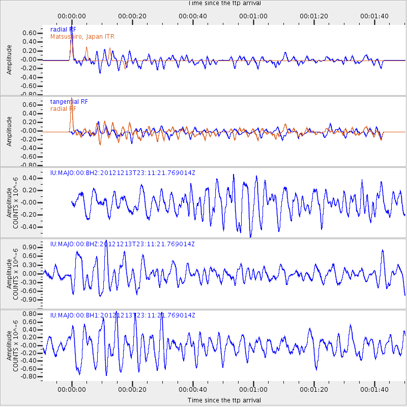
MAJO Matsushiro, Japan - Earthquake Result Viewer
*The percent match for this event was below the threshold and hence no stack was calculated.
| Earthquake location: |
East Of Severnaya Zemlya |
| Earthquake latitude/longitude: |
80.8/121.4 |
| Earthquake time(UTC): |
2012/12/13 (348) 23:03:38 GMT |
| Earthquake Depth: |
10 km |
| Earthquake Magnitude: |
5.7 MB, 5.1 MS, 5.5 MW, 5.6 MW |
| Earthquake Catalog/Contributor: |
WHDF/NEIC |
|
| Network: |
IU Global Seismograph Network (GSN - IRIS/USGS) |
| Station: |
MAJO Matsushiro, Japan |
| Lat/Lon: |
36.55 N/138.20 E |
| Elevation: |
405 m |
|
| Distance: |
44.8 deg |
| Az: |
160.699 deg |
| Baz: |
356.214 deg |
| Ray Param: |
$rayparam |
*The percent match for this event was below the threshold and hence was not used in the summary stack. |
|
| Radial Match: |
72.98639 % |
| Radial Bump: |
388 |
| Transverse Match: |
65.77716 % |
| Transverse Bump: |
400 |
| SOD ConfigId: |
558545 |
| Insert Time: |
2013-09-18 02:00:50.918 +0000 |
| GWidth: |
2.5 |
| Max Bumps: |
400 |
| Tol: |
0.001 |
|
Signal To Noise
| Channel | StoN | STA | LTA |
| IU:MAJO:00:BHZ:20121213T23:11:21.769014Z | 3.8113127 | 4.9010674E-7 | 1.2859263E-7 |
| IU:MAJO:00:BH1:20121213T23:11:21.769014Z | 3.6653516 | 4.4471625E-7 | 1.2132978E-7 |
| IU:MAJO:00:BH2:20121213T23:11:21.769014Z | 0.9821343 | 1.3166868E-7 | 1.3406382E-7 |
| Arrivals |
| Ps | |
| PpPs | |
| PsPs/PpSs | |


