You are here: Home > Network List > US - United States National Seismic Network Stations List
> Station MSO Missoula, Montana, USA > Earthquake Result Viewer
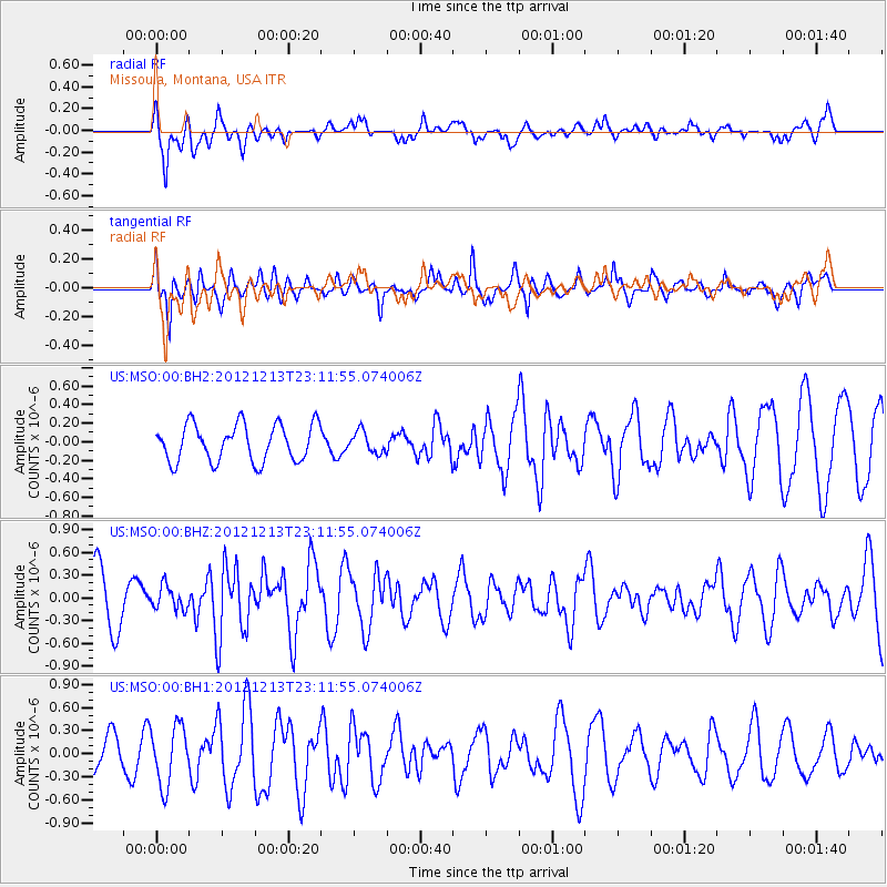
MSO Missoula, Montana, USA - Earthquake Result Viewer
*The percent match for this event was below the threshold and hence no stack was calculated.
| Earthquake location: |
East Of Severnaya Zemlya |
| Earthquake latitude/longitude: |
80.8/121.4 |
| Earthquake time(UTC): |
2012/12/13 (348) 23:03:38 GMT |
| Earthquake Depth: |
10 km |
| Earthquake Magnitude: |
5.7 MB, 5.1 MS, 5.5 MW, 5.6 MW |
| Earthquake Catalog/Contributor: |
WHDF/NEIC |
|
| Network: |
US United States National Seismic Network |
| Station: |
MSO Missoula, Montana, USA |
| Lat/Lon: |
46.83 N/113.94 W |
| Elevation: |
1264 m |
|
| Distance: |
49.1 deg |
| Az: |
48.333 deg |
| Baz: |
349.921 deg |
| Ray Param: |
$rayparam |
*The percent match for this event was below the threshold and hence was not used in the summary stack. |
|
| Radial Match: |
56.7571 % |
| Radial Bump: |
400 |
| Transverse Match: |
73.51098 % |
| Transverse Bump: |
400 |
| SOD ConfigId: |
558545 |
| Insert Time: |
2013-09-18 02:03:41.241 +0000 |
| GWidth: |
2.5 |
| Max Bumps: |
400 |
| Tol: |
0.001 |
|
Signal To Noise
| Channel | StoN | STA | LTA |
| US:MSO:00:BHZ:20121213T23:11:55.074006Z | 0.55488473 | 1.5281572E-7 | 2.7540085E-7 |
| US:MSO:00:BH1:20121213T23:11:55.074006Z | 1.9687335 | 3.809736E-7 | 1.9351202E-7 |
| US:MSO:00:BH2:20121213T23:11:55.074006Z | 0.572311 | 1.1402406E-7 | 1.9923444E-7 |
| Arrivals |
| Ps | |
| PpPs | |
| PsPs/PpSs | |


