MAJO Matsushiro, Japan - Earthquake Result Viewer
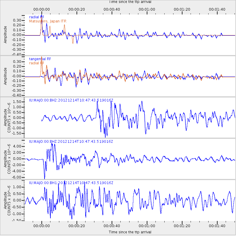
Earthquake location: Off W. Coast Of Baja California
Earthquake latitude/longitude: 31.1/-119.7
Earthquake time(UTC): 2012/12/14 (349) 10:36:01 GMT
Earthquake Depth: 13 km
Earthquake Magnitude: 6.2 MB, 6.1 MS, 6.3 MW, 6.4 MW
Earthquake Catalog/Contributor: WHDF/NEIC
Network: IU Global Seismograph Network (GSN - IRIS/USGS)
Station: MAJO Matsushiro, Japan
Lat/Lon: 36.55 N/138.20 E
Elevation: 405 m
Distance: 80.8 deg
Az: 307.108 deg
Baz: 58.162 deg
Ray Param: 0.04800938
Estimated Moho Depth: 30.5 km
Estimated Crust Vp/Vs: 1.60
Assumed Crust Vp: 6.461 km/s
Estimated Crust Vs: 4.038 km/s
Estimated Crust Poisson's Ratio: 0.18
Radial Match: 90.71879 %
Radial Bump: 400
Transverse Match: 87.57294 %
Transverse Bump: 400
SOD ConfigId: 558545
Insert Time: 2013-09-18 02:06:42.867 +0000
GWidth: 2.5
Max Bumps: 400
Tol: 0.001

Signal To Noise

ChannelStoNSTALTA
IU:MAJO:00:BHZ:20121214T10:47:43.519016Z21.3902032.32249E-61.08577275E-7
IU:MAJO:00:BH1:20121214T10:47:43.519016Z4.11210254.6913152E-71.1408556E-7
IU:MAJO:00:BH2:20121214T10:47:43.519016Z3.59442526.3730243E-71.7730301E-7
Arrivals
Ps2.9 SECOND
PpPs12 SECOND
PsPs/PpSs15 SECOND