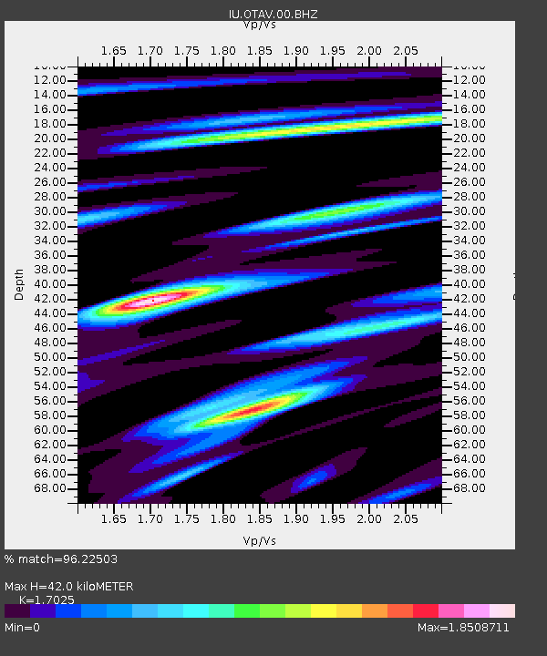
OTAV Otavalo, Ecuador - Earthquake Result Viewer
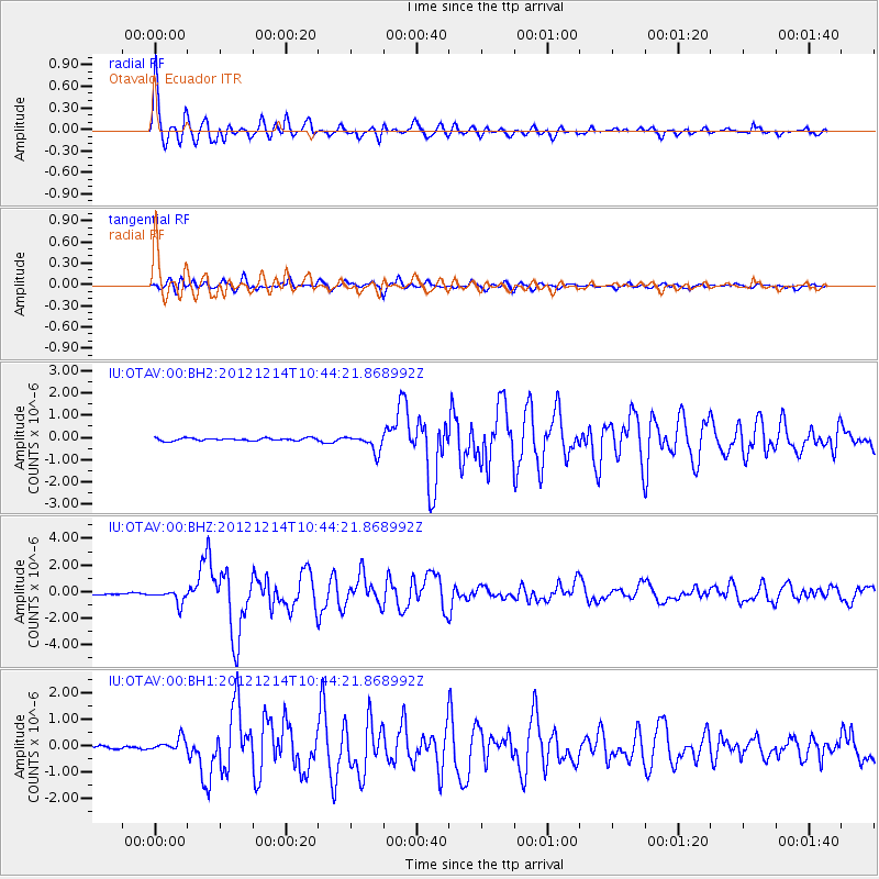
Earthquake location: Off W. Coast Of Baja California
Earthquake latitude/longitude: 31.1/-119.7
Earthquake time(UTC): 2012/12/14 (349) 10:36:01 GMT
Earthquake Depth: 13 km
Earthquake Magnitude: 6.2 MB, 6.1 MS, 6.3 MW, 6.4 MW
Earthquake Catalog/Contributor: WHDF/NEIC
Network: IU Global Seismograph Network (GSN - IRIS/USGS)
Station: OTAV Otavalo, Ecuador
Lat/Lon: 0.24 N/78.45 W
Elevation: 3510 m
Distance: 49.6 deg
Az: 120.178 deg
Baz: 312.133 deg
Ray Param: 0.068558976
Estimated Moho Depth: 42.0 km
Estimated Crust Vp/Vs: 1.70
Assumed Crust Vp: 6.472 km/s
Estimated Crust Vs: 3.801 km/s
Estimated Crust Poisson's Ratio: 0.24
Radial Match: 96.22503 %
Radial Bump: 400
Transverse Match: 88.62439 %
Transverse Bump: 400
SOD ConfigId: 558545
Insert Time: 2013-09-18 02:06:51.318 +0000
GWidth: 2.5
Max Bumps: 400
Tol: 0.001

Signal To Noise

ChannelStoNSTALTA
IU:OTAV:00:BHZ:20121214T10:44:21.868992Z7.7679255.3506574E-76.888142E-8
IU:OTAV:00:BH1:20121214T10:44:21.868992Z3.0357932.4895385E-78.20062E-8
IU:OTAV:00:BH2:20121214T10:44:21.868992Z6.2353233.793362E-76.0836655E-8
Arrivals
Ps4.9 SECOND
PpPs16 SECOND
PsPs/PpSs21 SECOND