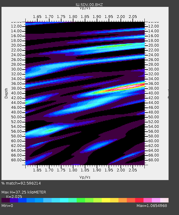
SDV Santo Domingo, Venezuela - Earthquake Result Viewer

Earthquake location: Off W. Coast Of Baja California
Earthquake latitude/longitude: 31.1/-119.7
Earthquake time(UTC): 2012/12/14 (349) 10:36:01 GMT
Earthquake Depth: 13 km
Earthquake Magnitude: 6.2 MB, 6.1 MS, 6.3 MW, 6.4 MW
Earthquake Catalog/Contributor: WHDF/NEIC
Network: IU Global Seismograph Network (GSN - IRIS/USGS)
Station: SDV Santo Domingo, Venezuela
Lat/Lon: 8.88 N/70.63 W
Elevation: 1620 m
Distance: 50.6 deg
Az: 105.105 deg
Baz: 303.058 deg
Ray Param: 0.06793794
Estimated Moho Depth: 37.25 km
Estimated Crust Vp/Vs: 2.03
Assumed Crust Vp: 6.192 km/s
Estimated Crust Vs: 3.058 km/s
Estimated Crust Poisson's Ratio: 0.34
Radial Match: 92.596214 %
Radial Bump: 355
Transverse Match: 79.20551 %
Transverse Bump: 400
SOD ConfigId: 558545
Insert Time: 2013-09-18 02:07:26.855 +0000
GWidth: 2.5
Max Bumps: 400
Tol: 0.001

Signal To Noise

ChannelStoNSTALTA
IU:SDV:00:BHZ:20121214T10:44:29.069004Z6.29432777.432319E-71.1807963E-7
IU:SDV:00:BH1:20121214T10:44:29.069004Z3.54169772.6736356E-77.549023E-8
IU:SDV:00:BH2:20121214T10:44:29.069004Z5.19044833.070202E-75.9151E-8
Arrivals
Ps6.5 SECOND
PpPs17 SECOND
PsPs/PpSs24 SECOND