You are here: Home > Network List > IU - Global Seismograph Network (GSN - IRIS/USGS) Stations List
> Station TEIG Tepich, Yucatan, Mexico > Earthquake Result Viewer
TEIG Tepich, Yucatan, Mexico - Earthquake Result Viewer

| Earthquake location: |
Off W. Coast Of Baja California |
| Earthquake latitude/longitude: |
31.1/-119.7 |
| Earthquake time(UTC): |
2012/12/14 (349) 10:36:01 GMT |
| Earthquake Depth: |
13 km |
| Earthquake Magnitude: |
6.2 MB, 6.1 MS, 6.3 MW, 6.4 MW |
| Earthquake Catalog/Contributor: |
WHDF/NEIC |
|
| Network: |
IU Global Seismograph Network (GSN - IRIS/USGS) |
| Station: |
TEIG Tepich, Yucatan, Mexico |
| Lat/Lon: |
20.23 N/88.28 W |
| Elevation: |
40 m |
|
| Distance: |
30.2 deg |
| Az: |
103.474 deg |
| Baz: |
297.334 deg |
| Ray Param: |
0.07939325 |
| Estimated Moho Depth: |
21.75 km |
| Estimated Crust Vp/Vs: |
2.01 |
| Assumed Crust Vp: |
5.817 km/s |
| Estimated Crust Vs: |
2.891 km/s |
| Estimated Crust Poisson's Ratio: |
0.34 |
|
| Radial Match: |
89.95282 % |
| Radial Bump: |
400 |
| Transverse Match: |
89.5085 % |
| Transverse Bump: |
400 |
| SOD ConfigId: |
558545 |
| Insert Time: |
2013-09-18 02:07:39.521 +0000 |
| GWidth: |
2.5 |
| Max Bumps: |
400 |
| Tol: |
0.001 |
|
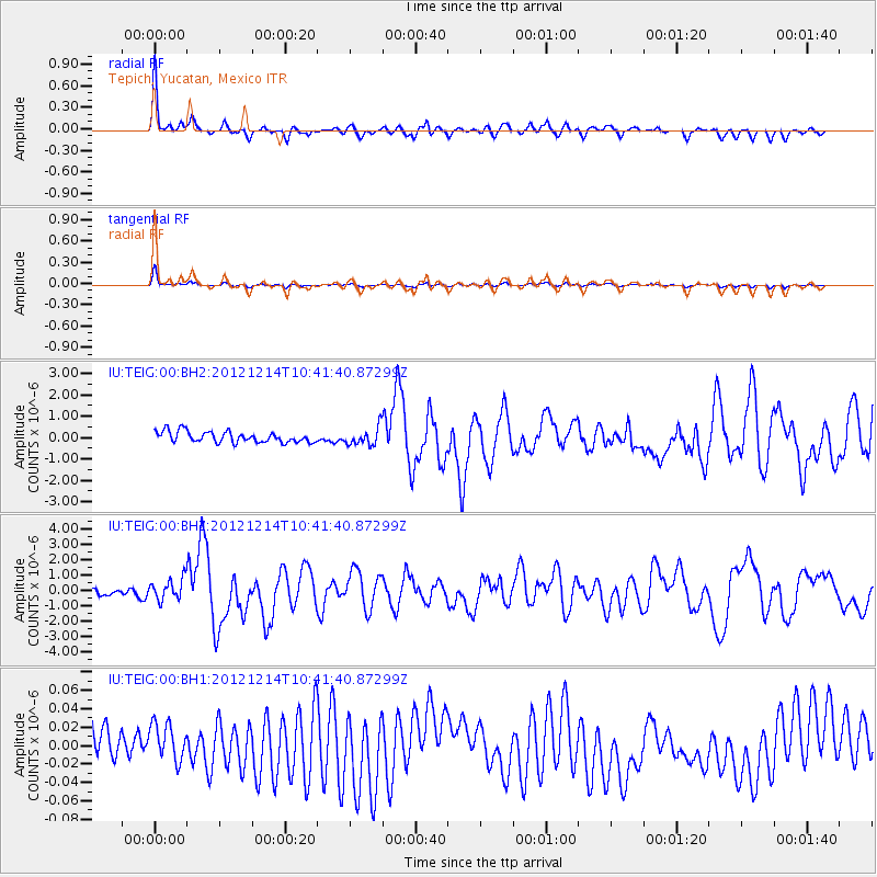
Signal To Noise
| Channel | StoN | STA | LTA |
| IU:TEIG:00:BHZ:20121214T10:41:40.87299Z | 3.5392468 | 7.0763076E-7 | 1.9993824E-7 |
| IU:TEIG:00:BH1:20121214T10:41:40.87299Z | 0.8541022 | 2.5114577E-8 | 2.9404651E-8 |
| IU:TEIG:00:BH2:20121214T10:41:40.87299Z | 1.6311815 | 4.1511402E-7 | 2.544867E-7 |
| Arrivals |
| Ps | 4.0 SECOND |
| PpPs | 11 SECOND |
| PsPs/PpSs | 15 SECOND |


