You are here: Home > Network List > II - Global Seismograph Network (GSN - IRIS/IDA) Stations List
> Station KAPI Kappang, Sulawesi, Indonesia > Earthquake Result Viewer
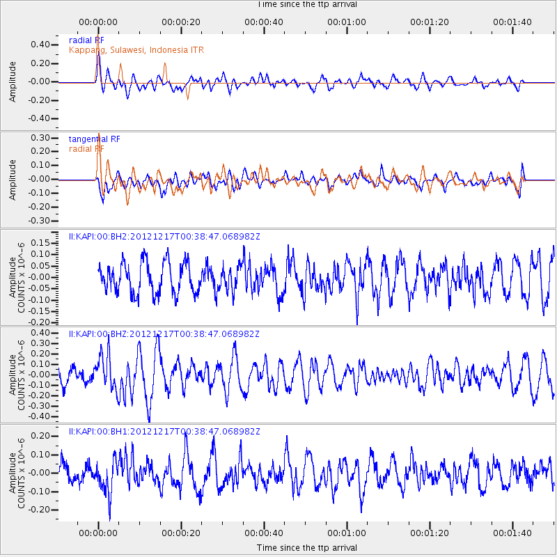
KAPI Kappang, Sulawesi, Indonesia - Earthquake Result Viewer
*The percent match for this event was below the threshold and hence no stack was calculated.
| Earthquake location: |
Kuril Islands |
| Earthquake latitude/longitude: |
49.8/155.8 |
| Earthquake time(UTC): |
2012/12/17 (352) 00:28:58 GMT |
| Earthquake Depth: |
68 km |
| Earthquake Magnitude: |
5.6 MW, 5.6 MW |
| Earthquake Catalog/Contributor: |
NEIC PDE/NEIC PDE-W |
|
| Network: |
II Global Seismograph Network (GSN - IRIS/IDA) |
| Station: |
KAPI Kappang, Sulawesi, Indonesia |
| Lat/Lon: |
5.01 S/119.75 E |
| Elevation: |
300 m |
|
| Distance: |
62.9 deg |
| Az: |
221.239 deg |
| Baz: |
25.398 deg |
| Ray Param: |
$rayparam |
*The percent match for this event was below the threshold and hence was not used in the summary stack. |
|
| Radial Match: |
58.23414 % |
| Radial Bump: |
400 |
| Transverse Match: |
49.532116 % |
| Transverse Bump: |
400 |
| SOD ConfigId: |
558545 |
| Insert Time: |
2013-09-18 02:23:04.558 +0000 |
| GWidth: |
2.5 |
| Max Bumps: |
400 |
| Tol: |
0.001 |
|
Signal To Noise
| Channel | StoN | STA | LTA |
| II:KAPI:00:BHZ:20121217T00:38:47.068982Z | 2.6090794 | 1.7199126E-7 | 6.592029E-8 |
| II:KAPI:00:BH1:20121217T00:38:47.068982Z | 1.948358 | 8.775024E-8 | 4.5038046E-8 |
| II:KAPI:00:BH2:20121217T00:38:47.068982Z | 0.75942254 | 5.101231E-8 | 6.71725E-8 |
| Arrivals |
| Ps | |
| PpPs | |
| PsPs/PpSs | |


