You are here: Home > Network List > IU - Global Seismograph Network (GSN - IRIS/USGS) Stations List
> Station CTAO Charters Towers, Australia > Earthquake Result Viewer
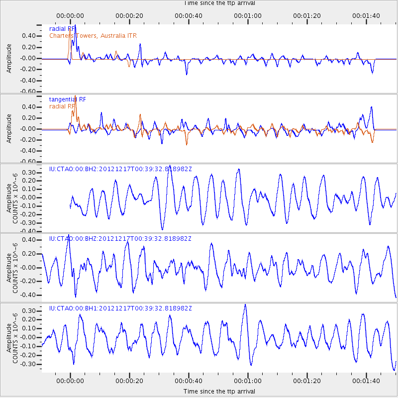
CTAO Charters Towers, Australia - Earthquake Result Viewer
*The percent match for this event was below the threshold and hence no stack was calculated.
| Earthquake location: |
Kuril Islands |
| Earthquake latitude/longitude: |
49.8/155.8 |
| Earthquake time(UTC): |
2012/12/17 (352) 00:28:58 GMT |
| Earthquake Depth: |
68 km |
| Earthquake Magnitude: |
5.6 MW, 5.6 MW |
| Earthquake Catalog/Contributor: |
NEIC PDE/NEIC PDE-W |
|
| Network: |
IU Global Seismograph Network (GSN - IRIS/USGS) |
| Station: |
CTAO Charters Towers, Australia |
| Lat/Lon: |
20.09 S/146.25 E |
| Elevation: |
357 m |
|
| Distance: |
70.1 deg |
| Az: |
189.58 deg |
| Baz: |
6.59 deg |
| Ray Param: |
$rayparam |
*The percent match for this event was below the threshold and hence was not used in the summary stack. |
|
| Radial Match: |
74.81076 % |
| Radial Bump: |
400 |
| Transverse Match: |
55.524693 % |
| Transverse Bump: |
400 |
| SOD ConfigId: |
558545 |
| Insert Time: |
2013-09-18 02:23:55.042 +0000 |
| GWidth: |
2.5 |
| Max Bumps: |
400 |
| Tol: |
0.001 |
|
Signal To Noise
| Channel | StoN | STA | LTA |
| IU:CTAO:00:BHZ:20121217T00:39:32.818982Z | 2.116177 | 2.301237E-7 | 1.0874501E-7 |
| IU:CTAO:00:BH1:20121217T00:39:32.818982Z | 1.8456221 | 1.7094025E-7 | 9.261932E-8 |
| IU:CTAO:00:BH2:20121217T00:39:32.818982Z | 2.3270483 | 2.634531E-7 | 1.1321342E-7 |
| Arrivals |
| Ps | |
| PpPs | |
| PsPs/PpSs | |


