You are here: Home > Network List > IU - Global Seismograph Network (GSN - IRIS/USGS) Stations List
> Station MAKZ Makanchi, Kazakhstan > Earthquake Result Viewer
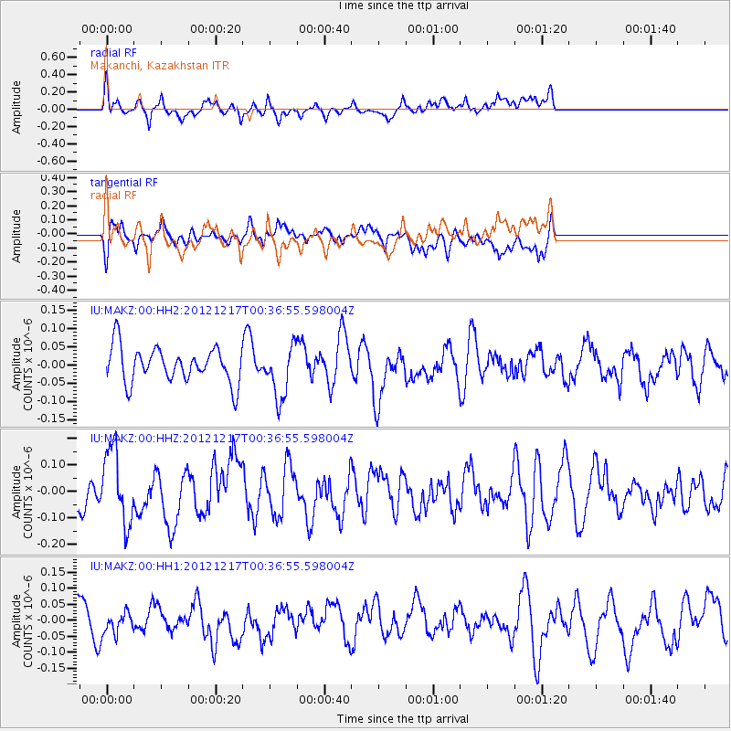
MAKZ Makanchi, Kazakhstan - Earthquake Result Viewer
*The percent match for this event was below the threshold and hence no stack was calculated.
| Earthquake location: |
Kuril Islands |
| Earthquake latitude/longitude: |
49.8/155.8 |
| Earthquake time(UTC): |
2012/12/17 (352) 00:28:58 GMT |
| Earthquake Depth: |
68 km |
| Earthquake Magnitude: |
5.6 MW, 5.6 MW |
| Earthquake Catalog/Contributor: |
NEIC PDE/NEIC PDE-W |
|
| Network: |
IU Global Seismograph Network (GSN - IRIS/USGS) |
| Station: |
MAKZ Makanchi, Kazakhstan |
| Lat/Lon: |
46.81 N/81.98 E |
| Elevation: |
600 m |
|
| Distance: |
47.4 deg |
| Az: |
296.271 deg |
| Baz: |
57.8 deg |
| Ray Param: |
$rayparam |
*The percent match for this event was below the threshold and hence was not used in the summary stack. |
|
| Radial Match: |
72.55791 % |
| Radial Bump: |
400 |
| Transverse Match: |
61.01101 % |
| Transverse Bump: |
400 |
| SOD ConfigId: |
558545 |
| Insert Time: |
2013-09-18 02:24:21.134 +0000 |
| GWidth: |
2.5 |
| Max Bumps: |
400 |
| Tol: |
0.001 |
|
Signal To Noise
| Channel | StoN | STA | LTA |
| IU:MAKZ:00:HHZ:20121217T00:36:55.598004Z | 2.4897945 | 1.3991382E-7 | 5.619493E-8 |
| IU:MAKZ:00:HH1:20121217T00:36:55.598004Z | 0.7088796 | 3.6417322E-8 | 5.1373075E-8 |
| IU:MAKZ:00:HH2:20121217T00:36:55.598004Z | 1.5061212 | 7.222807E-8 | 4.795635E-8 |
| Arrivals |
| Ps | |
| PpPs | |
| PsPs/PpSs | |


