You are here: Home > Network List > US - United States National Seismic Network Stations List
> Station BLA Blacksburg, Virginia, USA > Earthquake Result Viewer
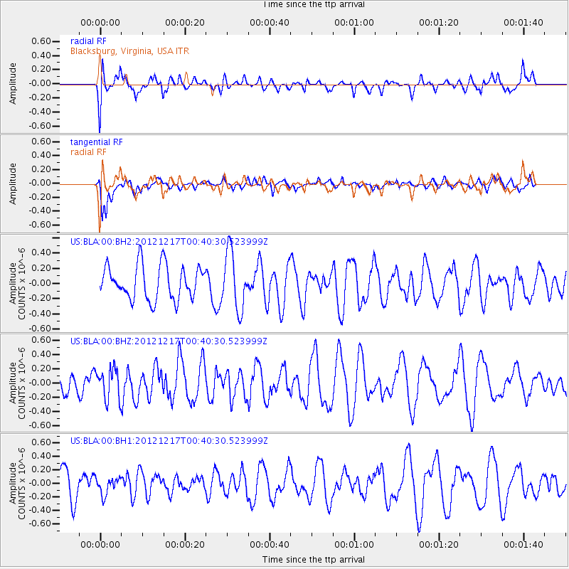
BLA Blacksburg, Virginia, USA - Earthquake Result Viewer
*The percent match for this event was below the threshold and hence no stack was calculated.
| Earthquake location: |
Kuril Islands |
| Earthquake latitude/longitude: |
49.8/155.8 |
| Earthquake time(UTC): |
2012/12/17 (352) 00:28:58 GMT |
| Earthquake Depth: |
68 km |
| Earthquake Magnitude: |
5.6 MW, 5.6 MW |
| Earthquake Catalog/Contributor: |
NEIC PDE/NEIC PDE-W |
|
| Network: |
US United States National Seismic Network |
| Station: |
BLA Blacksburg, Virginia, USA |
| Lat/Lon: |
37.21 N/80.42 W |
| Elevation: |
634 m |
|
| Distance: |
80.1 deg |
| Az: |
42.362 deg |
| Baz: |
326.834 deg |
| Ray Param: |
$rayparam |
*The percent match for this event was below the threshold and hence was not used in the summary stack. |
|
| Radial Match: |
61.65583 % |
| Radial Bump: |
400 |
| Transverse Match: |
59.23374 % |
| Transverse Bump: |
400 |
| SOD ConfigId: |
558545 |
| Insert Time: |
2013-09-18 02:25:38.424 +0000 |
| GWidth: |
2.5 |
| Max Bumps: |
400 |
| Tol: |
0.001 |
|
Signal To Noise
| Channel | StoN | STA | LTA |
| US:BLA:00:BHZ:20121217T00:40:30.523999Z | 0.9576264 | 2.159568E-7 | 2.2551258E-7 |
| US:BLA:00:BH1:20121217T00:40:30.523999Z | 0.40583292 | 1.1966453E-7 | 2.9486156E-7 |
| US:BLA:00:BH2:20121217T00:40:30.523999Z | 1.7079301 | 3.8273055E-7 | 2.2409029E-7 |
| Arrivals |
| Ps | |
| PpPs | |
| PsPs/PpSs | |


