You are here: Home > Network List > US - United States National Seismic Network Stations List
> Station WMOK Wichita Mountains, Oklahoma, USA > Earthquake Result Viewer
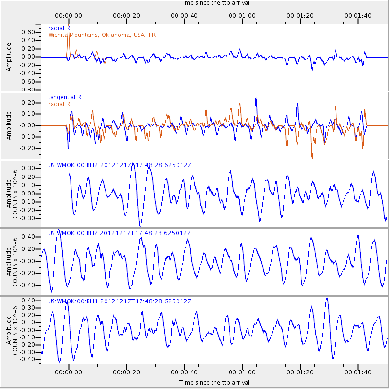
WMOK Wichita Mountains, Oklahoma, USA - Earthquake Result Viewer
*The percent match for this event was below the threshold and hence no stack was calculated.
| Earthquake location: |
Central East Pacific Rise |
| Earthquake latitude/longitude: |
-4.2/-104.5 |
| Earthquake time(UTC): |
2012/12/17 (352) 17:41:32 GMT |
| Earthquake Depth: |
10 km |
| Earthquake Magnitude: |
5.9 MW, 5.6 MS, 5.8 MW |
| Earthquake Catalog/Contributor: |
NEIC PDE/NEIC PDE-W |
|
| Network: |
US United States National Seismic Network |
| Station: |
WMOK Wichita Mountains, Oklahoma, USA |
| Lat/Lon: |
34.74 N/98.78 W |
| Elevation: |
486 m |
|
| Distance: |
39.1 deg |
| Az: |
7.473 deg |
| Baz: |
189.063 deg |
| Ray Param: |
$rayparam |
*The percent match for this event was below the threshold and hence was not used in the summary stack. |
|
| Radial Match: |
59.8423 % |
| Radial Bump: |
400 |
| Transverse Match: |
37.624836 % |
| Transverse Bump: |
326 |
| SOD ConfigId: |
558545 |
| Insert Time: |
2013-09-18 02:32:40.082 +0000 |
| GWidth: |
2.5 |
| Max Bumps: |
400 |
| Tol: |
0.001 |
|
Signal To Noise
| Channel | StoN | STA | LTA |
| US:WMOK:00:BHZ:20121217T17:48:28.625012Z | 1.0590494 | 2.1533755E-7 | 2.0333097E-7 |
| US:WMOK:00:BH1:20121217T17:48:28.625012Z | 1.9791481 | 2.665656E-7 | 1.3468703E-7 |
| US:WMOK:00:BH2:20121217T17:48:28.625012Z | 0.9786738 | 1.5470495E-7 | 1.580761E-7 |
| Arrivals |
| Ps | |
| PpPs | |
| PsPs/PpSs | |


