You are here: Home > Network List > US - United States National Seismic Network Stations List
> Station AMTX Amarillo, Texas, USA > Earthquake Result Viewer
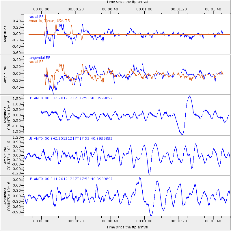
AMTX Amarillo, Texas, USA - Earthquake Result Viewer
*The percent match for this event was below the threshold and hence no stack was calculated.
| Earthquake location: |
Central East Pacific Rise |
| Earthquake latitude/longitude: |
-4.0/-104.2 |
| Earthquake time(UTC): |
2012/12/17 (352) 17:46:46 GMT |
| Earthquake Depth: |
10 km |
| Earthquake Magnitude: |
5.7 MW, 5.7 MW |
| Earthquake Catalog/Contributor: |
NEIC PDE/NEIC PDE-W |
|
| Network: |
US United States National Seismic Network |
| Station: |
AMTX Amarillo, Texas, USA |
| Lat/Lon: |
34.53 N/101.41 W |
| Elevation: |
1010 m |
|
| Distance: |
38.4 deg |
| Az: |
3.678 deg |
| Baz: |
184.445 deg |
| Ray Param: |
$rayparam |
*The percent match for this event was below the threshold and hence was not used in the summary stack. |
|
| Radial Match: |
46.225674 % |
| Radial Bump: |
400 |
| Transverse Match: |
36.471867 % |
| Transverse Bump: |
400 |
| SOD ConfigId: |
558545 |
| Insert Time: |
2013-09-18 02:34:44.318 +0000 |
| GWidth: |
2.5 |
| Max Bumps: |
400 |
| Tol: |
0.001 |
|
Signal To Noise
| Channel | StoN | STA | LTA |
| US:AMTX:00:BHZ:20121217T17:53:40.399989Z | 0.8063177 | 2.1380737E-7 | 2.651652E-7 |
| US:AMTX:00:BH1:20121217T17:53:40.399989Z | 1.0413975 | 1.540642E-7 | 1.4793987E-7 |
| US:AMTX:00:BH2:20121217T17:53:40.399989Z | 0.5344882 | 1.4361648E-7 | 2.6869904E-7 |
| Arrivals |
| Ps | |
| PpPs | |
| PsPs/PpSs | |


